Currently it only shows your basic business info. Start adding relevant business details such as description, images and products or services to gain your customers attention by using Boost 360
android app
/
iOS App/ web portal.
{
"products": [
{
"_id": "60ce35040f1ecb0001228d68",
"fptag": "EDUCAREADV",
"merchantname": null,
"customwidgets": null,
"externalsourceid": null,
"name": "RAM Structural System-Structural Design for Buildings Make Easy",
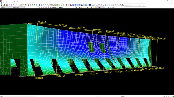
"description": "RAM Structural System-Complete Structural Design Software\n\nMoreover it save time and money by automating the most tedious, repetitive, and time-consuming project tasks. \nWhen you increase your productivity, you can focus on the more critical aspects of design and also provide a superior and more cost-effective solution to your client. \nRAM Structural System provides you a complete solution for analysis, design, drafting, and documentation for steel and concrete buildings, foundations, and even individual structural components. All the features are compliance with your local building codes. \nRAM Structural System helps engineers like you:\nSave countless hours with an intuitive modelling environment\nDesign structural steel and concrete elements, including foundations, to conform with design and building code provisions\nAnalyse the buildings’ lateral system for wind and seismic loads in the most practical way.\nCalculate the gravity load distribution across the structure using specialized methods, tailored to specific framing systems\nShare your structural data with applications such as Revit, Tekla, and Bentley’s OpenBuildings Designer\nSeamlessly integrate with complimentary applications like RAM Concept and RAM Connection to make the most of your RAM model\n\nStreamline your design and analysis workflows and gain the confidence that your designs will stand up to the test of time. Finally it deliver safe and optimized tilt-up wall designs, on time and on budget.\n\nCAPABILITIES\n\n\nANALYZE GRAVITY AND LATERAL LOAD\nDesign and analyze simple or complex structures for a wide range of loading conditions, including conditions induced by gravity like dead and live loads, such as skip conditions and tilt-up walls, in combination with lateral loads like wind and seismic.\n\nCOMPLY WITH SEISMIC REQUIREMENTS\nDesign and detail seismic force-resisting systems, generating seismic loads according to the relevant building code. Consider these forces in the design of elements and, where applicable, the design of frames and the larger structural system. Enforce the ductility requirements of the selected design code in element proportioning and detailing.\n\nDESIGN LATERAL RESISTING FRAMES\nPerform extensive building-code checks for seismic and wind forces on braced frames and moment frames. Quickly obtain safe and reliable designs for all of your structural projects.\n\nDESIGN TILT-UP WALLS\nCreate a single 3D model that includes your tilt-up walls and roof/floor systems. Simplify modeling accounts for analytical separation between adjacent walls and eccentric gravity loads on walls. Apply pressures with linearly varying magnitudes and automatic distribution over wall openings. Perform elastic second-order analysis for consideration of slenderness effects. Design concrete walls for out-of-plane and in-plane forces, with consideration of reveals and seismic provisions for special walls.\n\nDETAIL AND SCHEDULE CONCRETE REINFORCING\nProduce rebar placing drawings, including sections, plans, details, bar bending schedules, material take-offs and beam/column/footing schedules, all based on the 3D model. All schedules and drawings can be customized to adhere to your company’s standards for concrete projects.\n\nGENERATE DESIGN LOADS AND LOAD COMBINATIONS\nApply code-prescribed wind and seismic loads to the structure using built-in load generators. Calculate relevant loading parameters automatically based on the structural geometry, mass, and selected building code provisions without the need for separate hand calculations. Combine these lateral load cases with gravity and other types of loads using load combination generators.\n\nINTEGRATE SLAB AND FOUNDATION DESIGNS\nDesign slabs and foundations using specialized applications that are integrated within the master analysis model. Create design calculations and reinforcing drawings. Add the design information in BIM models by using ISM.\n\nPRODUCE STRUCTURAL DESIGN DOCUMENTATION\nGenerate structural design documents including necessary plans and elevations that are used to convey the design intent. Changes made to the 3D model are automatically updated in the documentation.",
"price": 337000.0,
"discountamount": 10000.0,
"currencycode": "INR",
"priority": 1000000,
"isfreeshipmentavailable": false,
"shipmentduration": 7,
"_keywords": null,
"isarchived": false,
"isavailable": false,
"applicationid": null,
"productindex": 26,
"imageuri": "https://productimages.withfloats.com/actual/60ce350c44a561000109fcdc.png",
"tileimageuri": "https://productimages.withfloats.com/tile/60ce350c44a561000109fcdc.png",
"images": null,
"totalqueries": 0,
"gpid": null,
"groupproductid": null,
"createdon": "2021-06-19T18:18:44.08Z",
"updatedon": "2023-04-12T12:21:21.864Z",
"buyonlinelink": null,
"producturl": "http://WWW.ADVEDUCARE.COM//ram-structural-system-structural-design-for-buildings-make-easy/26",
"availableunits": -1.0,
"iscodavailable": false,
"isprepaidonlineavailable": false,
"maxcodorders": 0,
"maxprepaidonlineorders": 0,
"uniquepaymenturl": null,
"brandname": "Bentley Systems",
"category": "Bentley Software",
"tags": [],
"variants": false,
"keyspecification": null,
"otherspecifications": null,
"pickupaddressreferenceid": "",
"paymenttype": "None",
"producttype": "products",
"hsncode": null,
"gstslab": 0.0,
"isnotforsale": false
},
{
"_id": "64dcc66c18b1700001ed979a",
"fptag": "EDUCAREADV",
"merchantname": null,
"customwidgets": null,
"externalsourceid": null,
"name": "MicroStation Virtuosity Annual Subscription",
"description": "MicroStation is the instrument professionals rely on to design, model, and manage infrastructure.\nIt’s more sophisticated than a tool, it’s an accessible instrument that offers power, control, efficiency, and security. It enables users to deliver innovative designs and creative visualizations and consolidates critical project elements in a single environment for effective, secure project deliverables.\n\nWith MicroStation, you can:\n\nModel anything, anywhere with geospatial context\nCreate conceptual and detailed drafting, drawing, and modeling for any industry\nDesign, communicate, and deliver your infrastructure projects in a single platform\n\n\n#Develop better design, faster\nDraft in 2D: Develop precise drawings using a comprehensive set of drafting tools to efficiently create 2D geometry. Rapidly progress your designs from concept to completion using persistent constraints to maintain your design intent.\n\nModel in 3D: Develop models in real context with a wide range of 3D modeling tools. Build and edit curve, surface, mesh, feature, and solids models. Build functional and parametric components with predefined variations to simplify managing and finding many similar components.\n\nDevelop Comprehensive Model Documentation: Present documentation and related design information within the spatial context of the 3D model to significantly improve their clarity. Embed links to related Microsoft Office documents and websites. Easily navigate from content in one file or model to others.\n\nAnalyze and Visualize Models: Analyze and visualize models based on their geometry or attributes. Detect and resolve clashes; perform analysis of real-world solar exposure and shading. Apply real-time display styles to visualize models based on each object’s height, slope, aspect angle, and other embedded properties.\n\nAccelerate Workflows: Speed design tasks and related workflows with intelligent interactive snapping. Improve productivity with the AccuDraw tool for dynamic data entry with heads-up display. Customize and group tools and tasks and reduce keystrokes with keyboard position mapping and the ability to customize cursor menus.\n\nSecure your Data: Ensure that only certain individuals can view and/or edit files. You can ensure the integrity of your documents using digital signatures and control the digital rights to view, edit, print, and copy file contents, including a pre-defined expiration date when the file can be accessed\n\n#Better Inform Teams\nCreate Animations Produce realistic movies and simulations from design, construction, and operational models with the built-in VUE rendering engine. Choose from keyframe and time-based animation. Get the results you want, faster, using live on-screen animation previews and distributed network processing.\n\nCreate Lifelike Renderings Create lifelike visualizations using a built-in VUE Rendering engine. Use online and delivered libraries of physically correct materials, lighting, and rich photorealistic content (RPC). Get results faster with distributed network rendering.\n\nGenerate Intelligent Documentation Generate consistent, high-quality paper and digital deliverables such as paper plots, reports, 2D/3D PDFs, and 3D physical models. Automate and speed annotation, display styles, and reports by generating them directly from the embedded properties of objects. This automates and speeds annotation display styles, and visual reports, and gives you confidence that they will always remain in sync with the model during work in progress.\n\nCreate Your Digital Twin Easily start synchronizing your existing designs with an iModel to take advantage of a Digital Twin. Share the Digital Twin with your project team to see the latest revisions and changes to the project.\n\nReview Designs Collaboratively Work in real-time with your project team members reviewing/tracking/ resolving with the Issue Resolution Service. Identify, assign, and review the progress of revisions and changes for any type of issue that arises in the model.\n\nMaintain and Enforce Standards Ensure the proper application of organizational and project specific standards. Apply templates to control geometry and data standards such as styles for dimensions, text, lines, detail symbols, and more. Once designs are complete, use automated tools to check drawings for standards compliance.\n\n#Freedom to focus on design\nGeospatially Locate Projects Integrate geospatial information from hundreds of supported coordinate systems into your designs. Access data from OGC Web Map Servers, use realtime GPS data, Microsoft Bing maps, and create and reference geospatial PDFs.\n\nIncorporate Common Design Formats Easily read, share, and consume precise data in key industry formats such as Autodesk®’s RealDWG™ (share and consume), IFC (read), Esri SHP (read), and more. Aggregate and assemble multiple file formats including PDF, U3D, 3DS, Rhino 3DM, IGES, Parasolid, ACIS SAT, CGM, STEP AP203/AP214, STL, OBJ, VRMLWorld, SketchUp SKP, and Collada.\n\nIncorporate Referenced Design Content View and work with design information from others in real-time using live referencing of 2D/3D DGN, DWG, and large image files, refreshed on demand. You can even natively reference PDF files into your designs.\n\nIntegrate Point Clouds Easily incorporate a wide range and scale of point-cloud data into the design environment. “Visualize, render, and measure point-cloud data to better understand existing conditions and speed dimensioning and modeling.\n\nIntegrate Raster Imagery Easily incorporate raster imagery of all types, including aerial and satellite imagery, and scanned documents. Choose from dozens of supported file formats including CALS, BMP, TIF, GeoTIFF, JPG, and many more.\n\nIntegrate Reality Meshes Incorporate realistic, photo-textured 3D models or reality meshes into your designs. These highly realistic models can be used directly in the design environment as the basis for your design and construction modeling for faster and better-quality models.\n\nManage Design Changes Track and easily understand changes made to design files, even at the component level, throughout their lifecycle. View, plot, and selectively roll back any individual changes made throughout the history of a file.\n\nWork in a Personalized Environment Confidently work in the right context for each project because the required settings and standards are automatically applied. Take advantage of personalized recommendations to help you get the most from your use of the software.\n\nExtend and Customize Workflows Streamline your workflow and integrate with enterprise systems using a wide range of available tools to customize the user interface. Develop solutions using Microsoft (VBA), .NET, C++, C# as well as user-defined macros.\n\n\n\n\n\n\n\n\n\n\n\n\n\n\n\n\nVIRTUOSO SUBSCRIPTION\nStay nimble and lower costs\n",
"price": 108077.0,
"discountamount": 5000.0,
"currencycode": "INR",
"priority": 1000000,
"isfreeshipmentavailable": false,
"shipmentduration": 7,
"_keywords": null,
"isarchived": false,
"isavailable": true,
"applicationid": null,
"productindex": 45,
"imageuri": "https://productimages.withfloats.com/actual/64dcc66f08869d0001dac4aa.png",
"tileimageuri": "https://productimages.withfloats.com/tile/64dcc66f08869d0001dac4aa.png",
"images": null,
"totalqueries": 0,
"gpid": null,
"groupproductid": null,
"createdon": "2023-08-16T12:51:56.922Z",
"updatedon": "2024-04-01T12:14:26.481Z",
"buyonlinelink": null,
"producturl": "http://WWW.ADVEDUCARE.COM/products/microstation-virtuosity-annual-subscription/45",
"availableunits": -1.0,
"iscodavailable": false,
"isprepaidonlineavailable": false,
"maxcodorders": 0,
"maxprepaidonlineorders": 0,
"uniquepaymenturl": null,
"brandname": "Bentley System",
"category": "Bentley Software",
"tags": [
"Microstation",
"lidar software",
"CAD SOFTWARE"
],
"variants": false,
"keyspecification": null,
"otherspecifications": null,
"pickupaddressreferenceid": "",
"paymenttype": "UniquePaymentUrl",
"producttype": "products",
"hsncode": null,
"gstslab": 0.0,
"isnotforsale": false
},
{
"_id": "64dc858c9b00660001a66cf2",
"fptag": "EDUCAREADV",
"merchantname": null,
"customwidgets": null,
"externalsourceid": null,
"name": "OpenRoads Designer Virtuosity-Annual Subscription License",
"description": "OpenRoads Designer creates road designs with construction-driven engineering and analysis\nOpenRoads Designer is an extremely versatile civil design application that is used for all types and sizes of civil projects around the world. The application addresses a wide variety of complex tasks such as interchange design, roundabout design, earthworks, surveying, sanitary and stormwater network design, subsurface utilities, and production of construction staking reports. Traditional 2D methods are manual and tedious, full of communication and data gaps, leaving you frustrated, exhausted, and with a project that costs you accuracy, time, and money. From survey through plan production and construction documentation, OpenRoads Designer is the one application you need to meet project requirements on time, every time, regardless of change.",
"price": 301001.0,
"discountamount": 10000.0,
"currencycode": "INR",
"priority": 1000000,
"isfreeshipmentavailable": false,
"shipmentduration": 7,
"_keywords": [
"time",
"money",
"sizes",
"world",
"types",
"reports",
"analysis",
"sanitary",
"accuracy",
"data gaps",
"surveying",
"earthworks",
"wide variety",
"road designs",
"complex tasks",
"communication",
"civil projects",
"plan production",
"one application",
"roundabout design",
"interchange design",
"subsurface utilities",
"project requirements",
"Traditional 2D methods",
"stormwater network design",
"construction documentation",
"construction-driven engineering",
"versatile civil design application",
"OpenRoads Designer Virtuosity-Annual Subscription License"
],
"isarchived": false,
"isavailable": true,
"applicationid": null,
"productindex": 40,
"imageuri": "https://productimages.withfloats.com/actual/64dc859ff3aede0001ad8bd0.jpg",
"tileimageuri": "https://productimages.withfloats.com/tile/64dc859ff3aede0001ad8bd0.jpg",
"images": null,
"totalqueries": 0,
"gpid": null,
"groupproductid": null,
"createdon": "2023-08-16T08:15:08.429Z",
"updatedon": "2023-08-16T08:15:08.429Z",
"buyonlinelink": null,
"producturl": "http://WWW.ADVEDUCARE.COM/products/openroads-designer-virtuosity-annual-subscription-license/40",
"availableunits": -1.0,
"iscodavailable": false,
"isprepaidonlineavailable": false,
"maxcodorders": 0,
"maxprepaidonlineorders": 0,
"uniquepaymenturl": null,
"brandname": "Bentley",
"category": "Bentley Software",
"tags": null,
"variants": false,
"keyspecification": null,
"otherspecifications": null,
"pickupaddressreferenceid": "",
"paymenttype": "None",
"producttype": "products",
"hsncode": null,
"gstslab": 0.0,
"isnotforsale": false
},
{
"_id": "60ce23098b30250001357faa",
"fptag": "EDUCAREADV",
"merchantname": null,
"customwidgets": null,
"externalsourceid": null,
"name": "STAAD.Pro Connect Edition ( Basic)-Perpetual License",
"description": "Perform comprehensive analysis and design for any size or type of structure faster than ever before using the new STAAD.Pro CONNECT Edition. Simplify your BIM workflow by using a physical model in STAAD.Pro that is automatically converted into the analytical model for your structural analysis. Share synchronized models with confidence for multi-discipline team collaboration and, most importantly, deliver safe, cost-effective designs. STAAD - Powerful Structural Analysis and Design Software!\n\nBecause every firm has different needs, there are three flexible STAAD.Pro options:\n\n\n\n1. STAAD.Pro – The most basic STAAD option including FEM analysis and physical modeling.\n\n2. STAAD.Pro Advanced – Adds faster, more advanced and complex analysis.\n\n3. Structural WorkSuite – The most popular structural applications in a single a cost-effective license.\nCAPABILITIES\nANALYZE GRAVITY AND LATERAL LOAD\nDesign and analyze simple or complex structures for a wide range of loading conditions, including conditions induced by gravity like dead and live loads, such as skip conditions and tilt-up walls, in combination with lateral loads like wind and seismic.\n\nCOMPLY WITH SEISMIC REQUIREMENTS\nDesign and detail seismic force-resisting systems, generating seismic loads according to the relevant building code. Consider these forces in the design of elements and, where applicable, the design of frames and the larger structural system. Enforce the ductility requirements of the selected design code in element proportioning and detailing.\n\nDESIGN AND ANALYZE STRUCTURAL MODELS\nQuickly model your entire structure, including decks, slabs, slab edges and openings, beams, columns, walls, braces, spread and continuous footings, and pile caps. Efficiently automate many of your time-consuming design and analysis tasks and produce practical system and component designs that are document ready.\n\nDESIGN AND ANALYZE WITH FINITE ELEMENTS\nComplete building analysis, design, and drafting for the entire structure accurately and efficiently using our state-of-the-art finite element analysis. Reduce or eliminate the time spent waiting for results using our fast solvers.\n\nDESIGN BEAMS, COLUMNS AND WALLS\nOptimize or analyze beams, columns, and walls for gravity and lateral loads to quickly obtain safe and economical designs. Confidently produce designs in compliance with global design specifications and building codes.\n\nDESIGN COLD-FORMED STEEL MEMBERS\nDesign light gauge steel members using a comprehensive cold-formed sections library without needing to use a separate special-purpose application.\n\nDESIGN LATERAL RESISTING FRAMES\nPerform extensive building-code checks for seismic and wind forces on braced frames and moment frames. Quickly obtain safe and reliable designs for all of your structural projects.\n\nDESIGN TO INTERNATIONAL STANDARDS\nExtend the reach of your business practice and take advantage of global design opportunities by using a wide range of international standards and specifications in our design products. Complete your designs with confidence thanks to extensive support of international standards.\n\nGENERATE DESIGN LOADS AND LOAD COMBINATIONS\nApply code-prescribed wind and seismic loads to the structure using built-in load generators. Calculate relevant loading parameters automatically based on the structural geometry, mass, and selected building code provisions without the need for separate hand calculations. Combine these lateral load cases with gravity and other types of loads using load combination generators.\n\nIMPORT SECTION SHAPES CREATED IN DXF\nQuickly import metric or imperial custom-defined section profiles detailed in DXF drawings. Alternatively define regular shapes with simple key dimensions or pick from a range of standard libraries.\n\nINTEGRATE SLAB AND FOUNDATION DESIGNS\nDesign slabs and foundations using specialized applications that are integrated within the master analysis model. Create design calculations and reinforcing drawings. Add the design information in BIM models by using ISM.\n\nINTEGRATE STEEL CONNECTION DESIGNS\nDesign structural steel connections within a single integrated environment. Transfer joint geometry, member sizes, and joint forces from the 3D analysis directly to the steel connection design application. This allows for efficient reuse of information and reduces the amount of rework required when the structure changes.\n\nPRODUCE SECTION PROPERTY REPORTS\nQuickly calculate section properties and easily produce detailed reports on your custom section profiles.\n\nPRODUCE STRUCTURAL DESIGN DOCUMENTATION\nGenerate structural design documents including necessary plans and elevations that are used to convey the design intent. Changes made to the 3D model are automatically updated in the documentation.\n\nSHARE STRUCTURAL MODELS\nTransfer structural model geometry and design results from one application to another and synchronize changes over time. Quickly share the structural model, drawings, and information with the entire team for review.\n\nUTILIZE INTERNATIONAL SECTION PROFILES\nComplete your structural model using a vast array of international section profile databases, which are included at no extra charge. Take advantage of global design opportunities around the world.",
"price": 200345.0,
"discountamount": 5345.0,
"currencycode": "INR",
"priority": 1000000,
"isfreeshipmentavailable": false,
"shipmentduration": 7,
"_keywords": null,
"isarchived": false,
"isavailable": false,
"applicationid": null,
"productindex": 25,
"imageuri": "https://productimages.withfloats.com/actual/60ce230a3c43ca0001f62a26.jpeg",
"tileimageuri": "https://productimages.withfloats.com/tile/60ce230a3c43ca0001f62a26.jpeg",
"images": null,
"totalqueries": 0,
"gpid": null,
"groupproductid": null,
"createdon": "2021-06-19T17:02:01.805Z",
"updatedon": "2023-08-16T07:44:37.694Z",
"buyonlinelink": null,
"producturl": "http://WWW.ADVEDUCARE.COM/products/staad-pro-connect-edition-basic-perpetual-license/25",
"availableunits": -1.0,
"iscodavailable": false,
"isprepaidonlineavailable": false,
"maxcodorders": 0,
"maxprepaidonlineorders": 0,
"uniquepaymenturl": null,
"brandname": "Bentley Systems",
"category": "Bentley Software",
"tags": [
"STAAD PRO",
"Structural design",
"SEL",
"Bnetley Systems"
],
"variants": false,
"keyspecification": null,
"otherspecifications": null,
"pickupaddressreferenceid": "",
"paymenttype": "None",
"producttype": "products",
"hsncode": null,
"gstslab": 0.0,
"isnotforsale": false
},
{
"_id": "60ce16598cf4610001575e3c",
"fptag": "EDUCAREADV",
"merchantname": null,
"customwidgets": null,
"externalsourceid": null,
"name": "Bentley ContextCapture Software",
"description": "CREATE 3D MODELS FROM SIMPLE PHOTOGRAPHS AND/OR POINT CLOUDS\n\nBentley ContextCapture can quickly produce most challenging 3D models of existing conditions for infrastructure projects. \nYou can use simple photographs or point clouds data for any projects. \nMoreover hybrid processing in ContextCapture enables the creation of engineering-ready reality meshes that incorporate the best of both worlds. The high-resolution photography supplemented, where needed, by additional accuracy of point clouds from laser scanning.\nExtend your capabilities to extract value from reality modeling data with ContextCapture Editor. The editor is a 3D CAD module for editing and analyzing reality data, included with ContextCapture.\n\nCAPABILITIES\n\n\nCONSUME IMAGERY FROM MANY CAMERAS AND SENSOR TYPES\nUtilize a wide variety of cameras, from smartphones to highly-specialized airborne or terrestrial multidirectional acquisition systems. Take advantage of any available image format and metadata to create 3D models.\n\nCONSUME LASERSCAN DATA\nImport static or mobile laserscan data. Combine it with photos to get very high accuracy reality meshes.\n\nCREATE ANIMATIONS, VIDEOS, AND FLY-THROUGHS\nProduce high-resolution orthographic and perspective images by rendering snapshots of any size. Set image size and scales using output rulers, scale, and positioning for accurate reuse. Take advantage of the intuitive time-based fly-through and object animation system for quick and easy movie production.\n\nCREATE HIGH-FIDELITY IMAGES\nUse high-fidelity imaging tools to support precision mapping and engineering. Combine imagery in virtually any format and projection.\n\nCREATE SCALABLE TERRAIN MODELS\nUse and display very large terrain models to increase return on investment on large datasets. Display scalable terrain models in a variety of modes, such as smooth shading with shadows, aspect angle, elevation, slope, contours, and more. Synchronize terrain models with source data such as DGN files, point-cloud data, and more.\n\nEMPLOY PARALLEL COMPUTING POWER\nDramatically reduce processing time with the ability to run two ContextCapture instances in parallel on a single project.\n\nGENERATE 2D AND 3D GIS MODELS\nProduce accurate georeferenced 3D models using a full range of geospatial data types including true orthophotos, point clouds, raster digital elevation models and Esri I3S format. Includes an SRS database interface to ensure interoperability with your GIS solution of choice.\n\nINTEGRATE DATA FROM MANY SOURCES WITH REALITY MESHES\nEnrich reality meshes with additional data like geospatial information, by attaching it to specific parts of the mesh, providing the ability to subsequently search and visualize regions of a mesh based on the associated data.\n\nINTEGRATE POSITIONING DATA\nLeverage ground control points or GPS tags to precisely georeference models. This enables you to geocoordinate your project and accurately measure coordinates, distances, areas, and volumes.\n\nMEASURE AND ANALYZE MODEL DATA\nSave time getting accurate answers by performing precise measurements of distances, volumes, and surface areas directly within the 3D viewing interface.\n\nMODEL GEOMETRY FROM REALITY MODELING DATA\nExtract break lines, paint lines, surfaces, planes, cylinder, and cylinder center lines from reality models. Efficiently clip and section point cloud and reality meshes to streamline vector extraction.\n\nPERFORM AUTOMATIC AEROTRIANGULATION AND 3D RECONSTRUCTION\nFully calibrate all images by automatically identifying the relative position and orientation of each photo. Employ automatic 3D reconstruction, texture mapping, and retexturing of ties and reconstruction constraints to ensure highly accurate models.\n\nPERFORM AUTOMATIC PHOTO BLOCK ALIGNMENT ON POINT CLOUDS\nDuring aerotriangulation process, automatically adjust the photo block to fit point clouds, resulting in precise calibration and alignment of the two data sources to create a high-fidelity reality mesh.\n\nPERFORM SIMULTANEOUS NAVIGATION AND VIEWING IN 2D IMAGES AND A 3D REALITY MESH\nTake advantage of photo navigation to analyze and perform quality assessment by clicking a point in the reality mesh to display full resolution photos and the synchronized 3D scene.\n\nPUBLISH AND VIEW WEB-READY MODELS\nProduce models of any size that are optimized for Web publishing and that can be viewed using a free plugin Web viewer. This enables instant sharing and visualization of 3D models on the Web.\n\nSCALABLE PRODUCTION SPEEDS WITH CLOUD ON-DEMAND\nMeet your most demanding deadlines with multi-engine cloud processing by switching to ContextCapture Cloud Processing Service directly from your ContextCapture desktop interface.\n\nVISUALIZE, ANALYZE, AND MEASURE REALITY MESHES PRIOR TO FINAL PRODUCTION\nTake advantage of the Splat display mode after aerotriangulation to view a draft of the reality mesh for faster insight to perform quality assessment, photo navigation, and measurement tasks.\n\nVISUALIZE, MANIPULATE AND EDIT REALITY MODELING DATA\nVisualize and edit point clouds with billions of points, changing their classification, color and removing or editing points. Manipulate reality meshes and scalable terrain models with hundreds of millions of triangles. Import, retouch, and export meshes in many formats.\nfurthermore may find more info by clicking the Link\nhttps://buystaad.in/p/2021/05/09/contextcapture/\n\n\n\n\n",
"price": 327339.0,
"discountamount": 0.0,
"currencycode": "INR",
"priority": 1000000,
"isfreeshipmentavailable": false,
"shipmentduration": 7,
"_keywords": null,
"isarchived": false,
"isavailable": false,
"applicationid": null,
"productindex": 24,
"imageuri": "https://productimages.withfloats.com/actual/60ce17f894a79600014ace2f.jpg",
"tileimageuri": "https://productimages.withfloats.com/tile/60ce17f894a79600014ace2f.jpg",
"images": null,
"totalqueries": 0,
"gpid": null,
"groupproductid": null,
"createdon": "2021-06-19T16:07:53.816Z",
"updatedon": "2023-08-16T07:45:53.548Z",
"buyonlinelink": null,
"producturl": "http://WWW.ADVEDUCARE.COM/products/bentley-contextcapture-software/24",
"availableunits": -1.0,
"iscodavailable": false,
"isprepaidonlineavailable": false,
"maxcodorders": 0,
"maxprepaidonlineorders": 0,
"uniquepaymenturl": null,
"brandname": "Bentley Systems",
"category": "Bentley Software",
"tags": [],
"variants": false,
"keyspecification": null,
"otherspecifications": null,
"pickupaddressreferenceid": "",
"paymenttype": "None",
"producttype": "products",
"hsncode": null,
"gstslab": 0.0,
"isnotforsale": false
},
{
"_id": "60cdb6a38cf461000157593f",
"fptag": "EDUCAREADV",
"merchantname": null,
"customwidgets": null,
"externalsourceid": null,
"name": "BricsCAD Lite ( 2D) Perpetual License ",
"description": "Familiar CAD\nLeverage what you already know with full command, script, macro and menu compatibility with the industry-standard CAD program. BricsCAD feels like home!\n\nBricsCAD Lite is highly compatible with AutoCAD® LT 2022\nThere’s no need to change your printers, templates, blocks or sheet set layouts to move to BricsCAD – they are 100% compatible. Command names, aliases, and system variables are the same in BricsCAD and AutoCAD®. BricsCAD is based on native DWG for the highest compatibility with other CAD users across all industries.\n\nCommand compatible\n\nMenu (.CUI, .CUIX) compatible\n\nMacro/script compatible\n\nSupport file (.PC3, .LIN, .PAT, .DWT, .SSM) compatible\n\nBased on latest DWG technology\n\n\nLISP Routines\nYou can run LISP routines developed in AutoCAD® and other CAD applications, and develop your own in the BricsCAD LISP Advanced Development Environment (BLADE). BricsCAD is based on OpenLISP, with modern memory management and great performance.\n\nWhy use Lisp?\nLisp routines are the easiest way to automate processes and workflows for bulk layer manipulations, changing entity properties, automate drawing and XREF relationships, standardize plotting and publishing workflows, etc.\n\nDynamic-Blocks\nUse your AutoCAD® Dynamic Blocks in BricsCAD\nYou can use the Dynamic Blocks that you created in AutoCAD® directly inside of BricsCAD. Control visibility states and stretch, flip, and rotate just as you would in AutoCAD®.\n\nEfficient CAD\nBricsCAD offers unique tools to help you get more work done faster. Many of them are powered by advanced machine learning technologies to accelerate tasks that can take hours or more via manual methods.",
"price": 29500.0,
"discountamount": 0.0,
"currencycode": "INR",
"priority": 1000000,
"isfreeshipmentavailable": false,
"shipmentduration": 7,
"_keywords": null,
"isarchived": false,
"isavailable": false,
"applicationid": null,
"productindex": 22,
"imageuri": "https://productimages.withfloats.com/actual/62cd350d87622a000152bade.png",
"tileimageuri": "https://productimages.withfloats.com/tile/62cd350d87622a000152bade.png",
"images": null,
"totalqueries": 0,
"gpid": null,
"groupproductid": null,
"createdon": "2021-06-19T09:19:31.796Z",
"updatedon": "2022-07-12T08:47:02.446Z",
"buyonlinelink": null,
"producturl": "http://WWW.ADVEDUCARE.COM/products/bricscad-lite-2d-perpetual-license-/22",
"availableunits": -1.0,
"iscodavailable": false,
"isprepaidonlineavailable": false,
"maxcodorders": 0,
"maxprepaidonlineorders": 0,
"uniquepaymenturl": null,
"brandname": "Bricsys ",
"category": "BricsCAD Software",
"tags": [
"AutoCAD",
"BricsCAD",
"2d Drafting Software"
],
"variants": false,
"keyspecification": null,
"otherspecifications": null,
"pickupaddressreferenceid": "",
"paymenttype": "UniquePaymentUrl",
"producttype": "products",
"hsncode": null,
"gstslab": 0.0,
"isnotforsale": false
},
{
"_id": "64dd1f369b00660001a67261",
"fptag": "EDUCAREADV",
"merchantname": null,
"customwidgets": null,
"externalsourceid": null,
"name": "Bentley OpenFlows WaterGEMS Virtuosity Annual Subscription -Unlimited Pipes",
"description": "Description\nDescription\nWaterGEMS is a hydraulic modeling software developed by Bentley Systems, designed for the analysis, design, and optimization of water distribution systems. It helps engineers and water professionals to simulate and analyze the behavior of water distribution networks. Here are some of the key features of WaterGEMS:\n\nHydraulic Analysis: WaterGEMS enables users to perform complex hydraulic analyses of water distribution networks. It models the flow of water, pressure variations, and other hydraulic characteristics throughout the system.\n\nNetwork Modeling: Users can create and manage detailed models of water distribution networks, including pipes, pumps, valves, tanks, reservoirs, and other components.\n\nDemand and Consumption Modeling: The software allows for the simulation of various water demand scenarios, helping to understand how changes in demand patterns impact the network's performance.\n\nLeak Detection and Management: WaterGEMS can assist in identifying and managing leaks within the distribution system by simulating pressure and flow data and comparing it to actual measurements.\n\nWater Quality Analysis: The software offers tools to model water quality aspects within the distribution network, including chlorine decay, contamination propagation, and disinfection processes.\n\nScenario Analysis: Users can evaluate different scenarios and strategies for network improvement, expansion, or maintenance to make informed decisions about system upgrades or changes.\n\nPressure Zone Management: WaterGEMS supports the creation and analysis of pressure zones within the distribution network, helping to optimize pressure levels and reduce energy consumption.\n\nPump Scheduling and Control: The software can optimize pump operation schedules and controls to minimize energy consumption and maintain desired pressure levels.\n\nIntegration with GIS: WaterGEMS can integrate with Geographic Information Systems (GIS) data, allowing users to import and utilize real-world geographical information for more accurate modeling.\n\nGraphical User Interface: The software provides an intuitive graphical interface that allows users to easily create, modify, and visualize their water distribution network models.\n\nReporting and Visualization: WaterGEMS offers tools for generating detailed reports, charts, and graphs to communicate analysis results and findings effectively.\n\nData Exchange: The software supports data exchange with other modeling and analysis tools, facilitating collaboration and integration into larger workflows.\n\nOptimization: Users can use WaterGEMS to optimize various aspects of the water distribution network, such as pipe sizing, pump placement, and valve settings to improve overall system efficiency and performance.\n\nModel Calibration: The software supports calibration of the model with real-world data to improve the accuracy of simulation results and better reflect the behavior of the actual distribution network.\n\nScenario Comparison: WaterGEMS allows users to compare the results of different scenarios side by side, aiding in the evaluation of different strategies and alternatives.\n\nOverall, WaterGEMS is a powerful tool that helps water engineers and professionals manage, analyze, and optimize water distribution systems to ensure efficient and reliable delivery of clean water to communities.",
"price": 869773.0,
"discountamount": 43500.0,
"currencycode": "INR",
"priority": 1000000,
"isfreeshipmentavailable": false,
"shipmentduration": 7,
"_keywords": [
"side",
"users",
"tanks",
"leaks",
"pumps",
"design",
"charts",
"valves",
"graphs",
"Control",
"changes",
"findings",
"creation",
"accuracy",
"behavior",
"Reporting",
"GIS) data",
"expansion",
"efficient",
"flow data",
"evaluation",
"reservoirs",
"pipe sizing",
"Description",
"communities",
"performance",
"maintenance",
"Integration",
"clean water",
"optimization",
"key features",
"alternatives",
"powerful tool",
"Visualization",
"Data Exchange",
"collaboration",
"Leak Detection",
"pressure zones",
"pump placement",
"analysis tools",
"other modeling",
"valve settings",
"chlorine decay",
"system upgrades",
"real-world data",
"various aspects",
"Bentley Systems",
"Pump Scheduling",
"detailed models",
"demand patterns",
"water engineers",
"Network Modeling",
"other components",
"analysis results",
"detailed reports",
"larger workflows",
"Model Calibration",
"reliable delivery",
"Scenario Analysis",
"accurate modeling",
"energy consumption",
"informed decisions",
"simulation results",
"Hydraulic Analysis",
"actual measurements",
"different scenarios",
"Scenario Comparison",
"water professionals",
"pressure variations",
"network improvement",
"different strategies",
"Consumption Modeling",
"water quality aspects",
"Water Quality Analysis",
"disinfection processes",
"desired pressure levels",
"pump operation schedules",
"Pressure Zone Management",
"Graphical User Interface",
"overall system efficiency",
"contamination propagation",
"water distribution systems",
"complex hydraulic analyses",
"actual distribution network",
"hydraulic modeling software",
"water distribution networks",
"intuitive graphical interface",
"Geographic Information Systems",
"various water demand scenarios",
"other hydraulic characteristics",
"water distribution network models",
"real-world geographical information",
"Bentley SoftOpenFlows WaterGEMS Virtuosity Annual Subscription Unlimited Pipes"
],
"isarchived": false,
"isavailable": true,
"applicationid": null,
"productindex": 61,
"imageuri": "https://productimages.withfloats.com/actual/64dd1f40b8fb930001d066cf.png",
"tileimageuri": "https://productimages.withfloats.com/tile/64dd1f40b8fb930001d066cf.png",
"images": null,
"totalqueries": 0,
"gpid": null,
"groupproductid": null,
"createdon": "2023-08-16T19:10:46.437Z",
"updatedon": "2024-04-01T12:01:49.785Z",
"buyonlinelink": null,
"producturl": "http://WWW.ADVEDUCARE.COM//bentley-openflows-watergems-virtuosity-annual-subscription-unlimited-pipes/61",
"availableunits": -1.0,
"iscodavailable": false,
"isprepaidonlineavailable": false,
"maxcodorders": 0,
"maxprepaidonlineorders": 0,
"uniquepaymenturl": null,
"brandname": "Bentley.com",
"category": "Bentley Software",
"tags": [
"watergems",
"water distribution",
"Bentley software",
"bentley systems"
],
"variants": false,
"keyspecification": null,
"otherspecifications": null,
"pickupaddressreferenceid": "",
"paymenttype": "UniquePaymentUrl",
"producttype": "products",
"hsncode": null,
"gstslab": 0.0,
"isnotforsale": false
},
{
"_id": "64dd1d686bde380001a9a336",
"fptag": "EDUCAREADV",
"merchantname": null,
"customwidgets": null,
"externalsourceid": null,
"name": "OpenFlows WaterGEMS Virtuosity Annual Subscription 10000 Pipes",
"description": "Description\nWaterGEMS is a hydraulic modeling software developed by Bentley Systems, designed for the analysis, design, and optimization of water distribution systems. It helps engineers and water professionals to simulate and analyze the behavior of water distribution networks. Here are some of the key features of WaterGEMS:\n\nHydraulic Analysis: WaterGEMS enables users to perform complex hydraulic analyses of water distribution networks. It models the flow of water, pressure variations, and other hydraulic characteristics throughout the system.\n\nNetwork Modeling: Users can create and manage detailed models of water distribution networks, including pipes, pumps, valves, tanks, reservoirs, and other components.\n\nDemand and Consumption Modeling: The software allows for the simulation of various water demand scenarios, helping to understand how changes in demand patterns impact the network's performance.\n\nLeak Detection and Management: WaterGEMS can assist in identifying and managing leaks within the distribution system by simulating pressure and flow data and comparing it to actual measurements.\n\nWater Quality Analysis: The software offers tools to model water quality aspects within the distribution network, including chlorine decay, contamination propagation, and disinfection processes.\n\nScenario Analysis: Users can evaluate different scenarios and strategies for network improvement, expansion, or maintenance to make informed decisions about system upgrades or changes.\n\nPressure Zone Management: WaterGEMS supports the creation and analysis of pressure zones within the distribution network, helping to optimize pressure levels and reduce energy consumption.\n\nPump Scheduling and Control: The software can optimize pump operation schedules and controls to minimize energy consumption and maintain desired pressure levels.\n\nIntegration with GIS: WaterGEMS can integrate with Geographic Information Systems (GIS) data, allowing users to import and utilize real-world geographical information for more accurate modeling.\n\nGraphical User Interface: The software provides an intuitive graphical interface that allows users to easily create, modify, and visualize their water distribution network models.\n\nReporting and Visualization: WaterGEMS offers tools for generating detailed reports, charts, and graphs to communicate analysis results and findings effectively.\n\nData Exchange: The software supports data exchange with other modeling and analysis tools, facilitating collaboration and integration into larger workflows.\n\nOptimization: Users can use WaterGEMS to optimize various aspects of the water distribution network, such as pipe sizing, pump placement, and valve settings to improve overall system efficiency and performance.\n\nModel Calibration: The software supports calibration of the model with real-world data to improve the accuracy of simulation results and better reflect the behavior of the actual distribution network.\n\nScenario Comparison: WaterGEMS allows users to compare the results of different scenarios side by side, aiding in the evaluation of different strategies and alternatives.\n\nOverall, WaterGEMS is a powerful tool that helps water engineers and professionals manage, analyze, and optimize water distribution systems to ensure efficient and reliable delivery of clean water to communities.\n",
"price": 695788.0,
"discountamount": 34000.0,
"currencycode": "INR",
"priority": 1000000,
"isfreeshipmentavailable": false,
"shipmentduration": 7,
"_keywords": [
"side",
"leaks",
"tanks",
"pumps",
"users",
"graphs",
"charts",
"design",
"valves",
"changes",
"Control",
"behavior",
"accuracy",
"creation",
"findings",
"flow data",
"GIS) data",
"efficient",
"expansion",
"Reporting",
"reservoirs",
"evaluation",
"pipe sizing",
"performance",
"Description",
"10000 Pipes",
"communities",
"Integration",
"clean water",
"maintenance",
"key features",
"alternatives",
"optimization",
"Visualization",
"Data Exchange",
"collaboration",
"powerful tool",
"pump placement",
"valve settings",
"analysis tools",
"pressure zones",
"other modeling",
"Leak Detection",
"chlorine decay",
"system upgrades",
"real-world data",
"Pump Scheduling",
"Bentley Systems",
"demand patterns",
"water engineers",
"detailed models",
"various aspects",
"larger workflows",
"Network Modeling",
"analysis results",
"detailed reports",
"other components",
"accurate modeling",
"Model Calibration",
"reliable delivery",
"Scenario Analysis",
"simulation results",
"Hydraulic Analysis",
"energy consumption",
"informed decisions",
"actual measurements",
"different scenarios",
"water professionals",
"Scenario Comparison",
"pressure variations",
"network improvement",
"different strategies",
"Consumption Modeling",
"water quality aspects",
"disinfection processes",
"Water Quality Analysis",
"desired pressure levels",
"pump operation schedules",
"Graphical User Interface",
"Pressure Zone Management",
"overall system efficiency",
"contamination propagation",
"water distribution systems",
"complex hydraulic analyses",
"hydraulic modeling software",
"water distribution networks",
"actual distribution network",
"intuitive graphical interface",
"various water demand scenarios",
"Geographic Information Systems",
"other hydraulic characteristics",
"water distribution network models",
"real-world geographical information",
"OpenFlows WaterGEMS Virtuosity Annual Subscription"
],
"isarchived": false,
"isavailable": true,
"applicationid": null,
"productindex": 60,
"imageuri": "https://productimages.withfloats.com/actual/64dd1e3c5b2f8700019e1cff.png",
"tileimageuri": "https://productimages.withfloats.com/tile/64dd1e3c5b2f8700019e1cff.png",
"images": null,
"totalqueries": 0,
"gpid": null,
"groupproductid": null,
"createdon": "2023-08-16T19:03:04.408Z",
"updatedon": "2024-04-01T12:03:04.441Z",
"buyonlinelink": null,
"producturl": "http://WWW.ADVEDUCARE.COM/products/openflows-watergems-virtuosity-annual-subscription-10000-pipes/60",
"availableunits": -1.0,
"iscodavailable": false,
"isprepaidonlineavailable": false,
"maxcodorders": 0,
"maxprepaidonlineorders": 0,
"uniquepaymenturl": null,
"brandname": "Bentley.com",
"category": "Bentley Software",
"tags": [
"watergems",
"water distribution",
"Bentley software",
"bentley systems"
],
"variants": false,
"keyspecification": null,
"otherspecifications": null,
"pickupaddressreferenceid": "",
"paymenttype": "UniquePaymentUrl",
"producttype": "products",
"hsncode": null,
"gstslab": 0.0,
"isnotforsale": false
},
{
"_id": "64dd1ce19b00660001a67258",
"fptag": "EDUCAREADV",
"merchantname": null,
"customwidgets": null,
"externalsourceid": null,
"name": "OpenFlows WaterGEMS Virtuosity Annual Subscription 5000 Pipes",
"description": "Description\nWaterGEMS is a hydraulic modeling software developed by Bentley Systems, designed for the analysis, design, and optimization of water distribution systems. It helps engineers and water professionals to simulate and analyze the behavior of water distribution networks. Here are some of the key features of WaterGEMS:\n\nHydraulic Analysis: WaterGEMS enables users to perform complex hydraulic analyses of water distribution networks. It models the flow of water, pressure variations, and other hydraulic characteristics throughout the system.\n\nNetwork Modeling: Users can create and manage detailed models of water distribution networks, including pipes, pumps, valves, tanks, reservoirs, and other components.\n\nDemand and Consumption Modeling: The software allows for the simulation of various water demand scenarios, helping to understand how changes in demand patterns impact the network's performance.\n\nLeak Detection and Management: WaterGEMS can assist in identifying and managing leaks within the distribution system by simulating pressure and flow data and comparing it to actual measurements.\n\nWater Quality Analysis: The software offers tools to model water quality aspects within the distribution network, including chlorine decay, contamination propagation, and disinfection processes.\n\nScenario Analysis: Users can evaluate different scenarios and strategies for network improvement, expansion, or maintenance to make informed decisions about system upgrades or changes.\n\nPressure Zone Management: WaterGEMS supports the creation and analysis of pressure zones within the distribution network, helping to optimize pressure levels and reduce energy consumption.\n\nPump Scheduling and Control: The software can optimize pump operation schedules and controls to minimize energy consumption and maintain desired pressure levels.\n\nIntegration with GIS: WaterGEMS can integrate with Geographic Information Systems (GIS) data, allowing users to import and utilize real-world geographical information for more accurate modeling.\n\nGraphical User Interface: The software provides an intuitive graphical interface that allows users to easily create, modify, and visualize their water distribution network models.\n\nReporting and Visualization: WaterGEMS offers tools for generating detailed reports, charts, and graphs to communicate analysis results and findings effectively.\n\nData Exchange: The software supports data exchange with other modeling and analysis tools, facilitating collaboration and integration into larger workflows.\n\nOptimization: Users can use WaterGEMS to optimize various aspects of the water distribution network, such as pipe sizing, pump placement, and valve settings to improve overall system efficiency and performance.\n\nModel Calibration: The software supports calibration of the model with real-world data to improve the accuracy of simulation results and better reflect the behavior of the actual distribution network.\n\nScenario Comparison: WaterGEMS allows users to compare the results of different scenarios side by side, aiding in the evaluation of different strategies and alternatives.\n\nOverall, WaterGEMS is a powerful tool that helps water engineers and professionals manage, analyze, and optimize water distribution systems to ensure efficient and reliable delivery of clean water to communities.\n",
"price": 521795.0,
"discountamount": 26000.0,
"currencycode": "INR",
"priority": 1000000,
"isfreeshipmentavailable": false,
"shipmentduration": 7,
"_keywords": [
"side",
"pumps",
"tanks",
"leaks",
"users",
"design",
"charts",
"valves",
"graphs",
"Control",
"changes",
"findings",
"creation",
"accuracy",
"behavior",
"Reporting",
"GIS) data",
"expansion",
"efficient",
"flow data",
"evaluation",
"reservoirs",
"pipe sizing",
"Description",
"communities",
"performance",
"maintenance",
"Integration",
"clean water",
"optimization",
"key features",
"alternatives",
"powerful tool",
"Visualization",
"Data Exchange",
"collaboration",
"Leak Detection",
"pressure zones",
"pump placement",
"analysis tools",
"other modeling",
"valve settings",
"chlorine decay",
"system upgrades",
"real-world data",
"detailed models",
"various aspects",
"Pump Scheduling",
"demand patterns",
"Bentley Systems",
"water engineers",
"Network Modeling",
"other components",
"analysis results",
"detailed reports",
"larger workflows",
"Model Calibration",
"reliable delivery",
"Scenario Analysis",
"accurate modeling",
"energy consumption",
"informed decisions",
"simulation results",
"Hydraulic Analysis",
"actual measurements",
"different scenarios",
"Scenario Comparison",
"water professionals",
"pressure variations",
"network improvement",
"different strategies",
"Consumption Modeling",
"water quality aspects",
"Water Quality Analysis",
"disinfection processes",
"desired pressure levels",
"pump operation schedules",
"Pressure Zone Management",
"Graphical User Interface",
"overall system efficiency",
"contamination propagation",
"water distribution systems",
"complex hydraulic analyses",
"hydraulic modeling software",
"actual distribution network",
"water distribution networks",
"intuitive graphical interface",
"Geographic Information Systems",
"various water demand scenarios",
"other hydraulic characteristics",
"water distribution network models",
"real-world geographical information",
"OpenFlows WaterGEMS Virtuosity Annual Subscription 5000 Pipes"
],
"isarchived": false,
"isavailable": true,
"applicationid": null,
"productindex": 59,
"imageuri": "https://productimages.withfloats.com/actual/64dd1cebae548b00013ef0b9.png",
"tileimageuri": "https://productimages.withfloats.com/tile/64dd1cebae548b00013ef0b9.png",
"images": null,
"totalqueries": 0,
"gpid": null,
"groupproductid": null,
"createdon": "2023-08-16T19:00:49.431Z",
"updatedon": "2024-04-01T12:03:58.216Z",
"buyonlinelink": null,
"producturl": "http://WWW.ADVEDUCARE.COM/products/openflows-watergems-virtuosity-annual-subscription-5000-pipes/59",
"availableunits": -1.0,
"iscodavailable": false,
"isprepaidonlineavailable": false,
"maxcodorders": 0,
"maxprepaidonlineorders": 0,
"uniquepaymenturl": null,
"brandname": "Bentley.com",
"category": "Bentley Software",
"tags": [
"watergems",
"water distribution",
"Bentley software",
"bentley systems"
],
"variants": false,
"keyspecification": null,
"otherspecifications": null,
"pickupaddressreferenceid": "",
"paymenttype": "UniquePaymentUrl",
"producttype": "products",
"hsncode": null,
"gstslab": 0.0,
"isnotforsale": false
}
],
"hasmoreitems": false,
"isapirequest": false,
"totalresults": 27,
"query": null,
"floatingpoint": null
}