Currently it only shows your basic business info. Start adding relevant business details such as description, images and products or services to gain your customers attention by using Boost 360
android app
/
iOS App/ web portal.
{
"products": [
{
"_id": "5b6b3a6c17b6bc0566d89fc0",
"fptag": "EDUCAREADV",
"merchantname": null,
"customwidgets": null,
"externalsourceid": null,
"name": "Bentley Academic Subscription Program( Class Room & Campus)",
"description": "Students can quickly become job-ready by using the same software industry professionals use. The Academic SELECT Subscription provides Institutions & Universities with access to comprehensive portfolio of more than 50 applications across the architecture, engineering, construction, and operations (AECO) disciplines. \n\n \nBridge Analysis\n LEAP Bridge Concrete\n LEAP Bridge Steel\n RM Bridge**\n\n \nBuilding Design\n AECOsim Building Designer\n AECOsim Energy Simulator\n GenerativeComponents\n Hevacomp Mechanical Designer\n Hevacomp Electrical Designer\n Hevacomp Dynamic Simulation\n\n\nCivil Design\n OpenRoads ConceptStation\n OpenRoads Designer\n GEOPAK Civil Engineering Suite\n InRoads Suite\n Bentley MXROAD Suite\n Power GEOPAK\n Power InRoads\n Bentley PowerCivil for Country\n Bentley topoGRAPH (Brazil only)\n Bentley Rail Track\n Power Rail Track\n Power Rail Overhead Line\n gINT Professional\n \n \nHydraulic and Hydrology\n WaterGEMS\n WaterCAD\n HAMMER\n SewerGEMS\n SewerCAD\n CivilStorm\n StormCAD\n PondPack\n CulvertMaster\n FlowMaster\n \n \nInfrastructure Asset Performance\n Bentley Map Enterprise\n Mine Design\n MineCycle Designer\n MineCycle Survey\n MineCycle Material Handling\n\n\nModeling and Visualization\n MicroStation\n MicroStation PowerDraft\n \n\nOffshore Structural Analysis\n MAXSURF Enterprise\n SACS Marine Enterprise**\n SACS Offshore Structure Enterprise**\n MOSES Advanced**\n \n\nPlant Design\n AutoPLANT Modeler\n OpenPlant PID\n OpenPlant Modeler\n OpenPlant Isometrics Manager\n Bentley AutoPIPE\n\n\n \nReality Modeling\n Bentley Descartes\n Bentley Pointools**\n ContextCapture\n LumenRT\n \n \nStructural Analysis\n Microstran\n STAAD.Pro\n STAAD Foundation Advanced\n RAM Structural System\n - RAM Steel\n - RAM Concrete\n - RAM Frame\n - RAM Foundation\n RAM Elements\n RAM Concept\n RAM Connection\n ProStructures\n - ProSteel\n - ProConcrete\n \n",
"price": 450000.0,
"discountamount": 10000.0,
"currencycode": "INR",
"priority": 1000000,
"isfreeshipmentavailable": false,
"shipmentduration": 0,
"_keywords": [
"Bentley Rail",
"RAM Structural",
"Bentley MXROAD",
"Bentley topoGRAPH",
"Bentley PowerCivil",
"Power Rail Overhead",
"Hevacomp Mechanical",
"Hevacomp Electrical",
"OpenPlant Isometrics",
"SACS Offshore Structure",
"comprehensive portfolio",
"GEOPAK Civil Engineering",
"Academic SELECT Subscription",
"software industry professionals",
"Bentley Academic Subscription Program"
],
"isarchived": false,
"isavailable": false,
"applicationid": null,
"productindex": 3,
"imageuri": "https://productimages.withfloats.com/actual/5a9abb6697d3890548b24bef.jpg",
"tileimageuri": "https://productimages.withfloats.com/tile/5a9abb6697d3890548b24bef.jpg",
"images": null,
"totalqueries": 0,
"gpid": null,
"groupproductid": null,
"createdon": "2018-03-03T14:58:36.285Z",
"updatedon": "2021-06-19T19:10:07.477Z",
"buyonlinelink": null,
"producturl": "http://WWW.ADVEDUCARE.COM/products/bentley-academic-subscription-program-class-room-campus-/3",
"availableunits": -1.0,
"iscodavailable": false,
"isprepaidonlineavailable": false,
"maxcodorders": 0,
"maxprepaidonlineorders": 0,
"uniquepaymenturl": null,
"brandname": "",
"category": "",
"tags": [],
"variants": false,
"keyspecification": null,
"otherspecifications": null,
"pickupaddressreferenceid": "",
"paymenttype": "UniquePaymentUrl",
"producttype": "products",
"hsncode": null,
"gstslab": 0.0,
"isnotforsale": false
},
{
"_id": "64dcc66c18b1700001ed979a",
"fptag": "EDUCAREADV",
"merchantname": null,
"customwidgets": null,
"externalsourceid": null,
"name": "MicroStation Virtuosity Annual Subscription",
"description": "MicroStation is the instrument professionals rely on to design, model, and manage infrastructure.\nIt’s more sophisticated than a tool, it’s an accessible instrument that offers power, control, efficiency, and security. It enables users to deliver innovative designs and creative visualizations and consolidates critical project elements in a single environment for effective, secure project deliverables.\n\nWith MicroStation, you can:\n\nModel anything, anywhere with geospatial context\nCreate conceptual and detailed drafting, drawing, and modeling for any industry\nDesign, communicate, and deliver your infrastructure projects in a single platform\n\n\n#Develop better design, faster\nDraft in 2D: Develop precise drawings using a comprehensive set of drafting tools to efficiently create 2D geometry. Rapidly progress your designs from concept to completion using persistent constraints to maintain your design intent.\n\nModel in 3D: Develop models in real context with a wide range of 3D modeling tools. Build and edit curve, surface, mesh, feature, and solids models. Build functional and parametric components with predefined variations to simplify managing and finding many similar components.\n\nDevelop Comprehensive Model Documentation: Present documentation and related design information within the spatial context of the 3D model to significantly improve their clarity. Embed links to related Microsoft Office documents and websites. Easily navigate from content in one file or model to others.\n\nAnalyze and Visualize Models: Analyze and visualize models based on their geometry or attributes. Detect and resolve clashes; perform analysis of real-world solar exposure and shading. Apply real-time display styles to visualize models based on each object’s height, slope, aspect angle, and other embedded properties.\n\nAccelerate Workflows: Speed design tasks and related workflows with intelligent interactive snapping. Improve productivity with the AccuDraw tool for dynamic data entry with heads-up display. Customize and group tools and tasks and reduce keystrokes with keyboard position mapping and the ability to customize cursor menus.\n\nSecure your Data: Ensure that only certain individuals can view and/or edit files. You can ensure the integrity of your documents using digital signatures and control the digital rights to view, edit, print, and copy file contents, including a pre-defined expiration date when the file can be accessed\n\n#Better Inform Teams\nCreate Animations Produce realistic movies and simulations from design, construction, and operational models with the built-in VUE rendering engine. Choose from keyframe and time-based animation. Get the results you want, faster, using live on-screen animation previews and distributed network processing.\n\nCreate Lifelike Renderings Create lifelike visualizations using a built-in VUE Rendering engine. Use online and delivered libraries of physically correct materials, lighting, and rich photorealistic content (RPC). Get results faster with distributed network rendering.\n\nGenerate Intelligent Documentation Generate consistent, high-quality paper and digital deliverables such as paper plots, reports, 2D/3D PDFs, and 3D physical models. Automate and speed annotation, display styles, and reports by generating them directly from the embedded properties of objects. This automates and speeds annotation display styles, and visual reports, and gives you confidence that they will always remain in sync with the model during work in progress.\n\nCreate Your Digital Twin Easily start synchronizing your existing designs with an iModel to take advantage of a Digital Twin. Share the Digital Twin with your project team to see the latest revisions and changes to the project.\n\nReview Designs Collaboratively Work in real-time with your project team members reviewing/tracking/ resolving with the Issue Resolution Service. Identify, assign, and review the progress of revisions and changes for any type of issue that arises in the model.\n\nMaintain and Enforce Standards Ensure the proper application of organizational and project specific standards. Apply templates to control geometry and data standards such as styles for dimensions, text, lines, detail symbols, and more. Once designs are complete, use automated tools to check drawings for standards compliance.\n\n#Freedom to focus on design\nGeospatially Locate Projects Integrate geospatial information from hundreds of supported coordinate systems into your designs. Access data from OGC Web Map Servers, use realtime GPS data, Microsoft Bing maps, and create and reference geospatial PDFs.\n\nIncorporate Common Design Formats Easily read, share, and consume precise data in key industry formats such as Autodesk®’s RealDWG™ (share and consume), IFC (read), Esri SHP (read), and more. Aggregate and assemble multiple file formats including PDF, U3D, 3DS, Rhino 3DM, IGES, Parasolid, ACIS SAT, CGM, STEP AP203/AP214, STL, OBJ, VRMLWorld, SketchUp SKP, and Collada.\n\nIncorporate Referenced Design Content View and work with design information from others in real-time using live referencing of 2D/3D DGN, DWG, and large image files, refreshed on demand. You can even natively reference PDF files into your designs.\n\nIntegrate Point Clouds Easily incorporate a wide range and scale of point-cloud data into the design environment. “Visualize, render, and measure point-cloud data to better understand existing conditions and speed dimensioning and modeling.\n\nIntegrate Raster Imagery Easily incorporate raster imagery of all types, including aerial and satellite imagery, and scanned documents. Choose from dozens of supported file formats including CALS, BMP, TIF, GeoTIFF, JPG, and many more.\n\nIntegrate Reality Meshes Incorporate realistic, photo-textured 3D models or reality meshes into your designs. These highly realistic models can be used directly in the design environment as the basis for your design and construction modeling for faster and better-quality models.\n\nManage Design Changes Track and easily understand changes made to design files, even at the component level, throughout their lifecycle. View, plot, and selectively roll back any individual changes made throughout the history of a file.\n\nWork in a Personalized Environment Confidently work in the right context for each project because the required settings and standards are automatically applied. Take advantage of personalized recommendations to help you get the most from your use of the software.\n\nExtend and Customize Workflows Streamline your workflow and integrate with enterprise systems using a wide range of available tools to customize the user interface. Develop solutions using Microsoft (VBA), .NET, C++, C# as well as user-defined macros.\n\n\n\n\n\n\n\n\n\n\n\n\n\n\n\n\nVIRTUOSO SUBSCRIPTION\nStay nimble and lower costs\n",
"price": 108077.0,
"discountamount": 5000.0,
"currencycode": "INR",
"priority": 1000000,
"isfreeshipmentavailable": false,
"shipmentduration": 7,
"_keywords": null,
"isarchived": false,
"isavailable": true,
"applicationid": null,
"productindex": 45,
"imageuri": "https://productimages.withfloats.com/actual/64dcc66f08869d0001dac4aa.png",
"tileimageuri": "https://productimages.withfloats.com/tile/64dcc66f08869d0001dac4aa.png",
"images": null,
"totalqueries": 0,
"gpid": null,
"groupproductid": null,
"createdon": "2023-08-16T12:51:56.922Z",
"updatedon": "2024-04-01T12:14:26.481Z",
"buyonlinelink": null,
"producturl": "http://WWW.ADVEDUCARE.COM/products/microstation-virtuosity-annual-subscription/45",
"availableunits": -1.0,
"iscodavailable": false,
"isprepaidonlineavailable": false,
"maxcodorders": 0,
"maxprepaidonlineorders": 0,
"uniquepaymenturl": null,
"brandname": "Bentley System",
"category": "Bentley Software",
"tags": [
"Microstation",
"lidar software",
"CAD SOFTWARE"
],
"variants": false,
"keyspecification": null,
"otherspecifications": null,
"pickupaddressreferenceid": "",
"paymenttype": "UniquePaymentUrl",
"producttype": "products",
"hsncode": null,
"gstslab": 0.0,
"isnotforsale": false
},
{
"_id": "64dc861f30ccad00013c87db",
"fptag": "EDUCAREADV",
"merchantname": null,
"customwidgets": null,
"externalsourceid": null,
"name": "Civil WorkSuite-Annual Subscription License",
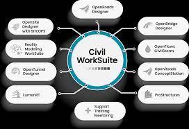
"description": "Field to finish solutions in one affordable bundle\nHaving the right tools when you need them is essential to meeting project demands. Whether you’re designing for road, site, bridge, or tunnel; Civil WorkSuite has your needs covered. The bundle includes Bentley’s industry leading purpose-built transportation solutions, such as OpenRoads Designer, OpenBridge Designer, OpenSite Designer, OpenTunnel Designer, and more. Plus, the inclusion of 3 keys provides access to expert services, mentoring, and customized training to minimize project downtime.\n\n\n#Civil WorkSuite includes the following software:\nOpenRoads Designer\nOpenRoads ConceptStation\nOpenBridge Designer\nOpenSite Designer\nOpenFlows CivilStorm (standalone, 250 links)\nBentley LumenRT\nProStructures\nReality Modeling WorkSuite\nOpenTunnel Designer\n",
"price": 245978.0,
"discountamount": 0.0,
"currencycode": "INR",
"priority": 1000000,
"isfreeshipmentavailable": false,
"shipmentduration": 7,
"_keywords": [
"needs",
"3 keys",
"access",
"Bentley",
"mentoring",
"inclusion",
"right tools",
"project demands",
"expert services",
"project downtime",
"OpenSite Designer",
"OpenRoads Designer",
"OpenTunnel Designer",
"OpenBridge Designer",
"customized training",
"Civil WorkSuite Field",
"one affordable bundle",
"industry leading purpose-built transportation solutions"
],
"isarchived": false,
"isavailable": true,
"applicationid": null,
"productindex": 41,
"imageuri": "https://productimages.withfloats.com/actual/64dc8639600851000117c33f.jpg",
"tileimageuri": "https://productimages.withfloats.com/tile/64dc8639600851000117c33f.jpg",
"images": null,
"totalqueries": 0,
"gpid": null,
"groupproductid": null,
"createdon": "2023-08-16T08:17:35.54Z",
"updatedon": "2023-08-16T11:12:26.909Z",
"buyonlinelink": null,
"producturl": "http://WWW.ADVEDUCARE.COM/products/civil-worksuite-annual-subscription-license/41",
"availableunits": -1.0,
"iscodavailable": false,
"isprepaidonlineavailable": false,
"maxcodorders": 0,
"maxprepaidonlineorders": 0,
"uniquepaymenturl": null,
"brandname": "Bentley",
"category": "Bentley Software",
"tags": [],
"variants": false,
"keyspecification": null,
"otherspecifications": null,
"pickupaddressreferenceid": "",
"paymenttype": "UniquePaymentUrl",
"producttype": "products",
"hsncode": null,
"gstslab": 0.0,
"isnotforsale": false
},
{
"_id": "64dc81d230ccad00013c8648",
"fptag": "EDUCAREADV",
"merchantname": null,
"customwidgets": null,
"externalsourceid": null,
"name": "PLAXIS 3D-Academic Bundle",
"description": "Plaxis 3D is a geotechnical engineering software developed by Bentley Systems that is used for the analysis and simulation of complex 3D geotechnical problems. It's widely used by engineers and geotechnical professionals to model and analyze various soil and rock behavior scenarios. Here are some of the key features of Plaxis 3D:\n\n#Geotechnical Analysis: \nPlaxis 3D allows for the comprehensive analysis of geotechnical problems involving soil-structure interaction, consolidation, stress and deformation, groundwater flow, and more.\n\n#3D Modeling: \nThe software specializes in three-dimensional modeling, enabling users to accurately simulate complex geometries, soil layers, structures, and construction sequences.\n\n#Material Models: \nPlaxis 3D offers a variety of material models to simulate the behavior of soils, rocks, and other geotechnical materials under different loading conditions.\n\n#Boundary Conditions: \nUsers can define various boundary conditions including fixed, prescribed displacement, or staged construction sequences to simulate real-world scenarios accurately.\n\n#Finite Element Analysis: \nThe software uses the finite element method to discretize and analyze complex geotechnical problems, allowing for accurate representation of soil behavior.\n\n#Soil-Structure Interaction: \nPlaxis 3D facilitates the modeling of interactions between soil and structures, including retaining walls, foundations, tunnels, and excavations.\n\n#Excavation and Construction Sequences: \nEngineers can simulate construction and excavation processes, studying the behavior of soil and structures during each stage of the project.\n\n#Dynamic Analysis: \nThe software can perform dynamic analyses to study the effects of seismic loads, vibrations, and other dynamic forces on soil-structure systems.\n\n#Groundwater Flow: \nPlaxis 3D can model groundwater flow and its impact on soil behavior, helping to assess factors such as pore pressure buildup and drainage conditions.\n\n#Meshing: \nThe software provides advanced meshing capabilities to create a finite element mesh that accurately represents the geometry and material interfaces of the problem.\n\n#Visualization: \nPlaxis 3D offers visualization tools to help users understand the behavior of the geotechnical system, including deformation, stress distribution, and groundwater flow paths.\n\n#Geosynthetic and Reinforcement Modeling: \nUsers can model the behavior of geosynthetic materials, reinforcements, and geogrids to study their impact on soil stability and behavior.\n\n#Parametric Studies: \nEngineers can perform parametric studies by varying input parameters to analyze how changes in material properties, geometries, or loading conditions affect the system's response.\n\n#Results and Output: \nThe software provides comprehensive output and reporting capabilities, including graphs, contour plots, and tables that help in interpreting and communicating analysis results.\n\n#Import and Export: \nPlaxis 3D supports data exchange with other software applications, enabling users to import geometries from CAD programs and export results to further analysis tools.\n\n#Tunneling and Deep Excavations: \nThe software is particularly well-suited\n",
"price": 1345860.0,
"discountamount": 0.0,
"currencycode": "INR",
"priority": 1000000,
"isfreeshipmentavailable": false,
"shipmentduration": 7,
"_keywords": [
"users",
"mining",
"stability",
"tunneling",
"foundations",
"embankments",
"excavations",
"deformation",
"geomechanics",
"rock mechanics",
"geotechnical risk",
"trusted computation",
"geotechnical engineers",
"geoengineering projects",
"subsurface environments",
"finite element analysis",
"geo-engineering projects",
"geotechnical engineering",
"PLAXIS 3D-Academic Bundle",
"CAD-like drawing capabilities",
"user-friendly, finite element package"
],
"isarchived": false,
"isavailable": true,
"applicationid": null,
"productindex": 37,
"imageuri": "https://productimages.withfloats.com/actual/64dc81d44db8d600010a99c7.png",
"tileimageuri": "https://productimages.withfloats.com/tile/64dc81d44db8d600010a99c7.png",
"images": null,
"totalqueries": 0,
"gpid": null,
"groupproductid": null,
"createdon": "2023-08-16T07:59:14.829Z",
"updatedon": "2023-08-16T19:15:29.975Z",
"buyonlinelink": null,
"producturl": "http://WWW.ADVEDUCARE.COM/products/plaxis-3d-academic-bundle/37",
"availableunits": -1.0,
"iscodavailable": false,
"isprepaidonlineavailable": false,
"maxcodorders": 0,
"maxprepaidonlineorders": 0,
"uniquepaymenturl": null,
"brandname": "Bently",
"category": "Bentley Software",
"tags": [
"Geotechnical Software",
"BENTLEY SYSTEMS",
"plaxis 3d",
"plaxis 2d",
"Bentley software"
],
"variants": false,
"keyspecification": null,
"otherspecifications": null,
"pickupaddressreferenceid": "",
"paymenttype": "None",
"producttype": "products",
"hsncode": null,
"gstslab": 0.0,
"isnotforsale": false
},
{
"_id": "64dc809318b1700001ed941d",
"fptag": "EDUCAREADV",
"merchantname": null,
"customwidgets": null,
"externalsourceid": null,
"name": "Plaxis 2D- 15 User Academic Bundle",
"description": "PLAXIS 2D is a user-friendly, finite-element package that provides you with the ability to model diverse geotechnical problems from a single, integrated application. You can analyze the deformation and stability of projects ranging from excavations, embankments, and foundations to tunneling, mining, and geomechanics.\nPlaxis 2D is a geotechnical engineering software developed by Bentley Systems. It is used for the analysis and simulation of 2D geotechnical problems, providing a comprehensive toolset for engineers and geotechnical professionals to model and analyze various soil-structure interactions. Here are some of the key features of Plaxis 2D:\n\n#Geotechnical Analysis: \nPlaxis 2D allows for the detailed analysis of geotechnical problems involving soil behavior, consolidation, stress and deformation, groundwater flow, and more.\n\n#2D Modeling: \nThe software is specialized for two-dimensional modeling, enabling users to simulate various soil profiles, structures, and construction sequences in a simplified plane.\n\n#Material Models: \nPlaxis 2D offers a wide range of material models to simulate the behavior of soils, rocks, and other geotechnical materials under different loading and environmental conditions.\n\n#Boundary Conditions: \nUsers can define different types of boundary conditions to simulate real-world scenarios accurately, including fixed boundaries, prescribed displacements, and staged construction sequences.\n\n#Finite Element Analysis: \nPlaxis 2D employs the finite element method to discretize and analyze complex geotechnical problems, allowing for an accurate representation of soil behavior.\n\n#Soil-Structure Interaction: \nThe software facilitates the modeling of interactions between soil and structures such as retaining walls, foundations, embankments, and excavations.\n\n#Excavation and Construction Sequences: \nEngineers can simulate construction and excavation processes, observing how soil and structures respond at each stage of the project.\n\n#Groundwater Flow: \nPlaxis 2D can model groundwater flow and its influence on soil behavior, aiding in the assessment of factors like pore pressure changes and drainage conditions.\n\n#Dynamic Analysis: \nThe software allows for dynamic analyses, helping users understand the effects of seismic loads, vibrations, and other dynamic forces on soil-structure systems.\n\n#Meshing: \nPlaxis 2D provides meshing tools to create a finite element mesh that accurately represents the geometry and material interfaces of the problem.\n\n#Visualization: \nThe software offers visualization tools to help users interpret the behavior of the geotechnical system, including deformation, stress distribution, and groundwater flow paths.\n\n#Geosynthetic and Reinforcement Modeling: \nUsers can model the behavior of geosynthetic materials, reinforcements, and geogrids to study their impact on soil stability and behavior.\n\n#Parametric Studies: \nEngineers can perform parametric studies by varying input parameters to analyze how changes in material properties, geometries, or loading conditions affect the system's response.\n\n#Results and Output: \nPlaxis 2D provides comprehensive output and reporting capabilities, including graphs, contour plots, and tables that assist in interpreting and communicating analysis results.\n\n#Import and Export: \nThe software supports data exchange with other applications, allowing users to import geometries from CAD programs and export results to further analysis tools.\n\n#Slope Stability Analysis: \nPlaxis 2D is particularly useful for analyzing slope stability, assessing factors like soil strength, groundwater seepage, and external loading.\n\nPlaxis 2D is a versatile tool that empowers geotechnical engineers to model, simulate, and analyze the behavior of geotechnical systems in two dimensions, aiding in the design and execution of various construction and infrastructure projects.\n",
"price": 660480.0,
"discountamount": 0.0,
"currencycode": "INR",
"priority": 1000000,
"isfreeshipmentavailable": false,
"shipmentduration": 7,
"_keywords": [
"mining",
"ability",
"projects",
"tunneling",
"deformation",
"excavations",
"embankments",
"foundations",
"geomechanics",
"Plaxis 2D- Academic",
"diverse geotechnical problems",
"single, integrated application",
"user-friendly, finite-element package"
],
"isarchived": false,
"isavailable": true,
"applicationid": null,
"productindex": 36,
"imageuri": "https://productimages.withfloats.com/actual/64dc809737d291000135f193.png",
"tileimageuri": "https://productimages.withfloats.com/tile/64dc809737d291000135f193.png",
"images": null,
"totalqueries": 0,
"gpid": null,
"groupproductid": null,
"createdon": "2023-08-16T07:53:55.195Z",
"updatedon": "2023-08-16T19:20:43.328Z",
"buyonlinelink": null,
"producturl": "http://WWW.ADVEDUCARE.COM/products/plaxis-2d-15-user-academic-bundle/36",
"availableunits": -1.0,
"iscodavailable": false,
"isprepaidonlineavailable": false,
"maxcodorders": 0,
"maxprepaidonlineorders": 0,
"uniquepaymenturl": null,
"brandname": "Bentley ",
"category": "Bentley Software",
"tags": [
"Geotechnical Software",
"BENTLEY SYSTEMS",
"plaxis 3d",
"plaxis 2d",
"Bentley software"
],
"variants": false,
"keyspecification": null,
"otherspecifications": null,
"pickupaddressreferenceid": "",
"paymenttype": "None",
"producttype": "products",
"hsncode": null,
"gstslab": 0.0,
"isnotforsale": false
},
{
"_id": "60cdbb5720795a0001175af0",
"fptag": "EDUCAREADV",
"merchantname": null,
"customwidgets": null,
"externalsourceid": null,
"name": "BricsCAD Pro (3D) Perpetual",
"description": "CAD software for 2D drafting, 3D Modeling & 3rd party apps. \nFamiliar CAD\n\nLeverage what you already know with full command, script, macro and menu compatibility with the industry-standard CAD program. BricsCAD feels like home!\nFull functionalities of AutoCAD and more \nFor more info:-\nhttps://web.s-cdn.boostkit.dev/webaction-files/597c6bbfee786c8284e8d3bb_uploadpdf/bricscadv20forautocadusers-en_intl-5f475494221f0400010de19e.pdf\n",
"price": 67200.0,
"discountamount": 0.0,
"currencycode": "INR",
"priority": 1000000,
"isfreeshipmentavailable": false,
"shipmentduration": 7,
"_keywords": null,
"isarchived": false,
"isavailable": false,
"applicationid": null,
"productindex": 23,
"imageuri": "https://productimages.withfloats.com/actual/62cd3379e315b80001f38559.png",
"tileimageuri": "https://productimages.withfloats.com/tile/62cd3379e315b80001f38559.png",
"images": null,
"totalqueries": 0,
"gpid": null,
"groupproductid": null,
"createdon": "2021-06-19T09:39:35.054Z",
"updatedon": "2023-08-16T07:46:13.192Z",
"buyonlinelink": null,
"producturl": "http://WWW.ADVEDUCARE.COM/products/bricscad-pro-3d-perpetual/23",
"availableunits": -1.0,
"iscodavailable": false,
"isprepaidonlineavailable": false,
"maxcodorders": 0,
"maxprepaidonlineorders": 0,
"uniquepaymenturl": null,
"brandname": "Bricsys",
"category": "BricsCAD Software",
"tags": [
"AutoCAD",
"bricscad",
"Autocad alternative"
],
"variants": false,
"keyspecification": null,
"otherspecifications": null,
"pickupaddressreferenceid": "",
"paymenttype": "UniquePaymentUrl",
"producttype": "products",
"hsncode": null,
"gstslab": 0.0,
"isnotforsale": false
},
{
"_id": "5c3329d3e53adf000157286a",
"fptag": "EDUCAREADV",
"merchantname": null,
"customwidgets": null,
"externalsourceid": null,
"name": "Structural Enterprise Bundle (ALL Bentley STAAD & RAM Products)",
"description": "Included Products in STRUCTURAL ENTERPRISE BUNDLE-\n1. STAAD.Pro Advanced\n 1.1 STAAD.Pro\n 1.2 Advanced Analysis\n 1.3 Advanced Concrete Design (RCDC)\n2. STAAD Foundation Advanced\n3. RAM Structural System\n 3.1 RAM Steel\n 3.2 RAM Frame Analysis\n 3.3 RAM Frame Steel Design\n 3.4 RAM Concrete\n 3.5 RAM Foundation\n4. RAM Concept\n5. RAM Concept Post Tension\n6. RAM Elements\n7• RAM Connection\n8• Microstran.Advanced\n9• Microstran Design Code\n10• Limcon\n11• Limcon Design Code\n12• RCDC-FE\n13• Structural Synchronizer\n\nUse what you want, when you want it, with our bundled software suite of STAAD, RAM, and Microstran. These applications have been proven worldwide for decades in the design of infrastructure projects both large and small. You get reduced upfront costs, simplified business transactions, and the power of interoperability at your fingertips. Benefits to you include: \n1. Complete workflows\n2. Greater reuse of information\n3. Unlimited access for each user\n4. Lower cost of ownership\n\nWith Structural Enterprise, you can design in any infrastructure sector, with multiple materials, using any analysis method that is appropriate for the job. Structural Enterprise helps you: \n1. Design structural components such as timber members, trusses, masonry walls, concrete tilt-up walls, retaining walls, and foundations using RAM Elements.\n2. Design industrial and civil structures using STAAD.Pro Advanced, RAM Connection, and STAAD Foundation Advanced.\n3. Design multi-story concrete buildings using RAM Frame Analysis, RAM Concrete, RAM Concept, and RAM Foundation.\n4. Design multi-story steel buildings using RAM Steel, RAM Frame Analysis, RAM Frame Steel Design, RAM Connection, and RAM Foundation.\n5. Design industrial structures using Microstran, Limcon, and STAAD Foundation Advanced.\n\n",
"price": 461152.0,
"discountamount": 10000.0,
"currencycode": "INR",
"priority": 1000000,
"isfreeshipmentavailable": false,
"shipmentduration": 7,
"_keywords": null,
"isarchived": false,
"isavailable": false,
"applicationid": null,
"productindex": 17,
"imageuri": "https://productimages.withfloats.com/actual/60ce20010a84d2000139fb59.jpeg",
"tileimageuri": "https://productimages.withfloats.com/tile/60ce20010a84d2000139fb59.jpeg",
"images": null,
"totalqueries": 0,
"gpid": null,
"groupproductid": null,
"createdon": "2019-01-07T10:28:35.231Z",
"updatedon": "2023-08-16T06:02:26.395Z",
"buyonlinelink": null,
"producturl": "http://WWW.ADVEDUCARE.COM/products/structural-enterprise-bundle-all-bentley-staad-ram-products-/17",
"availableunits": -1.0,
"iscodavailable": false,
"isprepaidonlineavailable": false,
"maxcodorders": 0,
"maxprepaidonlineorders": 0,
"uniquepaymenturl": null,
"brandname": "Bentley Systems",
"category": "Bentley Software",
"tags": [
"STAAD PRO ADVANCED",
"STAAD PRO",
"RCDC",
"STRUCTURAL ENTERPRISE",
"RCDC FE",
"STAAD FOUNDATION ADVANCED",
"STRUCTURAL DESIGN SOFTWARE",
"E-TEB",
"STAAD PRO CONNECT EDITION",
"BENTLEY",
"E-TAB",
"BUY STAAD PRO",
"CONNECT EDITION"
],
"variants": false,
"keyspecification": null,
"otherspecifications": null,
"pickupaddressreferenceid": "",
"paymenttype": "UniquePaymentUrl",
"producttype": "products",
"hsncode": null,
"gstslab": 0.0,
"isnotforsale": false
},
{
"_id": "5b6b3a6d17b6bc0566d8a096",
"fptag": "EDUCAREADV",
"merchantname": null,
"customwidgets": null,
"externalsourceid": null,
"name": "SewerGems Perpetual License- 1000 Pipes",
"description": "Modeling Software for Sanitary and Combined Sewers\n \nIf building and preparing your sewer models feels like a never-ending task, SewerGEMS software is for you.\n \nSewerGEMS streamlines the modeling process, so that you have more time for solving wastewater engineering problems, such as improving capacity and limiting sewer overflows, which ultimately enable utilities to comply with sewer regulations set by regulatory agencies.\n \nFor more than three decades, SewerGEMS has provided utilities and wastewater professionals like you with advanced engineering tools to plan, design, maintain, and operate sanitary and combined sewer systems, including:\n \nEngineering decision guidance tools: Leverage SewerGEMS’ what-if scenario management tools to gain a better understanding of the behavior of your wastewater system, improving decision making and response time.\nImproved model accuracy: A well calibrated model decreases the risks of making poor decisions by ensuring that the model uses the best available data. SewerGEMS calibration tools such as SCADA integration enable you to rely on your model results.\nIncreased information mobility: SewerGEMS’ full GIS, CAD, and SCADA interoperability enables the cost-effective sharing and flow of information between utilities’ design, engineering, GIS, and operation departments, and their consultants. You can leverage the data that the utility invested in once and reuse across departments.\nSewerGEMS is a superset of SewerCAD.\n \nCAPABILITIES\n \nAllocate and estimate sanitary loads\n \nApply hydrographs, patterned loads, and unit loads using a comprehensive and customizable engineering library. Use the LoadBuilder module to leverage consumption, flow monitoring, land use, or census data in your GIS to automatically estimate and import sanitary loads for your sewer model.\nAllocate and estimate stormwater loads\n \nLoad models with wet weather runoff flows derived from precipitation using the built-in rainfall distributions or user-defined rainfall events. Runoff flows are computed using the most appropriate runoff method for the project.\nAnalyze hydraulics and combined sewer overflows\n \nEasily switch among multiple solvers according to the type of system you are analyzing: Saint Venant equations, convex/gradually varied flow solver (steady-state analysis for extreme flow conditions and extended period simulations), and rational/gradually varied flow solver.\nAnalyze hydrogen sulfide formation\n \nIdentify areas in your network that are at risk of damage from hydrogen sulfide (H2S) formation, which can lead to potential collapses if not addressed. Produce average concentration runs, display result maps of the network, and compare H2S formation according to various conditions such as temperature.\nAnalyze inlet capacities\n \nCalculate the proportion of stormwater runoff that will enter an inlet versus the proportion that will be carried downstream in a gutter or pond on the road surface. Quickly confirm that the spread of flow in a gutter doesn’t exceed design requirements.\nBuild and manage hydraulic models\n \nJumpstart the model-building process and manage your model effectively, so that you can focus on making the best engineering decisions. Leverage and import virtually any external data format, which maximizes ROI on geospatial and engineering data, and automate terrain extraction and node allocation.\nDesign and analyze culverts\n \nSelect from a library of standard culvert shapes, materials, and entrance conditions, then compute culvert headwater and tailwater elevations using calculation methodologies outlined in Hydraulic Design Series Number 5 from the U.S. Federal Highway Administration.\nDesign and analyze low impact development controls\n \nModel the effect that low impact development controls have in retaining runoff before it enters the stormwater system.\nDesign and analyze pond and outlets\n \nLeverage PondMaker’s guiding process through the confusing maze of pond design steps by following the step-by-step process that provides constant feedback on how the design is progressing. Set the maximum outflow rate, estimate storage, and check the outlet design and final design.\nDesign sanitary sewers\n \nMinimize capital investments by simply entering your design restrictions: velocities, slopes, cover depths, and pipe and manhole matching offsets. SewerCAD/SewerGEMS recommends the most cost-effective pipe sizes and invert elevations, avoiding unnecessary pipe trench excavation, while meeting design restrictions.\nDesign stormwater systems\n \nMinimize capital investments by simply entering your design restrictions: velocities, slopes, cover depths, and pipe and inlet matching offsets. The software product recommends the most cost-effective pipe sizes and invert elevations, avoiding unnecessary pipe trench excavation, while meeting design restrictions.\nSimulate water quality\n \nSimulate the generation, inflow, and transportation and treatment of any number of user-defined pollutants, such as total suspended solids or heavy metals.",
"price": 892507.0,
"discountamount": 10000.0,
"currencycode": "INR",
"priority": 1000000,
"isfreeshipmentavailable": false,
"shipmentduration": 7,
"_keywords": [
"pond design steps",
"design restrictions",
"import sanitary loads",
"extreme flow conditions",
"appropriate runoff method",
"scenario management tools",
"advanced engineering tools",
"SewerGEMS calibration tools",
"Produce average concentration",
"analyze low impact development",
"wastewater engineering problems",
"low impact development controls",
"customizable engineering library",
"Hydraulic Design Series Number 5",
"unnecessary pipe trench excavation"
],
"isarchived": false,
"isavailable": false,
"applicationid": null,
"productindex": 6,
"imageuri": "https://productimages.withfloats.com/actual/5aaa54e0c9e1f50adc6038d1.jpg",
"tileimageuri": "https://productimages.withfloats.com/tile/5aaa54e0c9e1f50adc6038d1.jpg",
"images": null,
"totalqueries": 0,
"gpid": null,
"groupproductid": null,
"createdon": "2018-03-15T11:11:29.006Z",
"updatedon": "2023-08-16T06:19:19.92Z",
"buyonlinelink": null,
"producturl": "http://WWW.ADVEDUCARE.COM/products/sewergems-perpetual-license-1000-pipes/6",
"availableunits": -1.0,
"iscodavailable": false,
"isprepaidonlineavailable": false,
"maxcodorders": 0,
"maxprepaidonlineorders": 0,
"uniquepaymenturl": null,
"brandname": "Bentley Systems",
"category": "Bentley Software",
"tags": [
"openflow",
"SewerGEMS"
],
"variants": false,
"keyspecification": null,
"otherspecifications": null,
"pickupaddressreferenceid": "",
"paymenttype": "UniquePaymentUrl",
"producttype": "products",
"hsncode": null,
"gstslab": 0.0,
"isnotforsale": false
},
{
"_id": "64dd1f369b00660001a67261",
"fptag": "EDUCAREADV",
"merchantname": null,
"customwidgets": null,
"externalsourceid": null,
"name": "Bentley OpenFlows WaterGEMS Virtuosity Annual Subscription -Unlimited Pipes",
"description": "Description\nDescription\nWaterGEMS is a hydraulic modeling software developed by Bentley Systems, designed for the analysis, design, and optimization of water distribution systems. It helps engineers and water professionals to simulate and analyze the behavior of water distribution networks. Here are some of the key features of WaterGEMS:\n\nHydraulic Analysis: WaterGEMS enables users to perform complex hydraulic analyses of water distribution networks. It models the flow of water, pressure variations, and other hydraulic characteristics throughout the system.\n\nNetwork Modeling: Users can create and manage detailed models of water distribution networks, including pipes, pumps, valves, tanks, reservoirs, and other components.\n\nDemand and Consumption Modeling: The software allows for the simulation of various water demand scenarios, helping to understand how changes in demand patterns impact the network's performance.\n\nLeak Detection and Management: WaterGEMS can assist in identifying and managing leaks within the distribution system by simulating pressure and flow data and comparing it to actual measurements.\n\nWater Quality Analysis: The software offers tools to model water quality aspects within the distribution network, including chlorine decay, contamination propagation, and disinfection processes.\n\nScenario Analysis: Users can evaluate different scenarios and strategies for network improvement, expansion, or maintenance to make informed decisions about system upgrades or changes.\n\nPressure Zone Management: WaterGEMS supports the creation and analysis of pressure zones within the distribution network, helping to optimize pressure levels and reduce energy consumption.\n\nPump Scheduling and Control: The software can optimize pump operation schedules and controls to minimize energy consumption and maintain desired pressure levels.\n\nIntegration with GIS: WaterGEMS can integrate with Geographic Information Systems (GIS) data, allowing users to import and utilize real-world geographical information for more accurate modeling.\n\nGraphical User Interface: The software provides an intuitive graphical interface that allows users to easily create, modify, and visualize their water distribution network models.\n\nReporting and Visualization: WaterGEMS offers tools for generating detailed reports, charts, and graphs to communicate analysis results and findings effectively.\n\nData Exchange: The software supports data exchange with other modeling and analysis tools, facilitating collaboration and integration into larger workflows.\n\nOptimization: Users can use WaterGEMS to optimize various aspects of the water distribution network, such as pipe sizing, pump placement, and valve settings to improve overall system efficiency and performance.\n\nModel Calibration: The software supports calibration of the model with real-world data to improve the accuracy of simulation results and better reflect the behavior of the actual distribution network.\n\nScenario Comparison: WaterGEMS allows users to compare the results of different scenarios side by side, aiding in the evaluation of different strategies and alternatives.\n\nOverall, WaterGEMS is a powerful tool that helps water engineers and professionals manage, analyze, and optimize water distribution systems to ensure efficient and reliable delivery of clean water to communities.",
"price": 869773.0,
"discountamount": 43500.0,
"currencycode": "INR",
"priority": 1000000,
"isfreeshipmentavailable": false,
"shipmentduration": 7,
"_keywords": [
"side",
"users",
"tanks",
"leaks",
"pumps",
"design",
"charts",
"valves",
"graphs",
"Control",
"changes",
"findings",
"creation",
"accuracy",
"behavior",
"Reporting",
"GIS) data",
"expansion",
"efficient",
"flow data",
"evaluation",
"reservoirs",
"pipe sizing",
"Description",
"communities",
"performance",
"maintenance",
"Integration",
"clean water",
"optimization",
"key features",
"alternatives",
"powerful tool",
"Visualization",
"Data Exchange",
"collaboration",
"Leak Detection",
"pressure zones",
"pump placement",
"analysis tools",
"other modeling",
"valve settings",
"chlorine decay",
"system upgrades",
"real-world data",
"various aspects",
"Bentley Systems",
"Pump Scheduling",
"detailed models",
"demand patterns",
"water engineers",
"Network Modeling",
"other components",
"analysis results",
"detailed reports",
"larger workflows",
"Model Calibration",
"reliable delivery",
"Scenario Analysis",
"accurate modeling",
"energy consumption",
"informed decisions",
"simulation results",
"Hydraulic Analysis",
"actual measurements",
"different scenarios",
"Scenario Comparison",
"water professionals",
"pressure variations",
"network improvement",
"different strategies",
"Consumption Modeling",
"water quality aspects",
"Water Quality Analysis",
"disinfection processes",
"desired pressure levels",
"pump operation schedules",
"Pressure Zone Management",
"Graphical User Interface",
"overall system efficiency",
"contamination propagation",
"water distribution systems",
"complex hydraulic analyses",
"actual distribution network",
"hydraulic modeling software",
"water distribution networks",
"intuitive graphical interface",
"Geographic Information Systems",
"various water demand scenarios",
"other hydraulic characteristics",
"water distribution network models",
"real-world geographical information",
"Bentley SoftOpenFlows WaterGEMS Virtuosity Annual Subscription Unlimited Pipes"
],
"isarchived": false,
"isavailable": true,
"applicationid": null,
"productindex": 61,
"imageuri": "https://productimages.withfloats.com/actual/64dd1f40b8fb930001d066cf.png",
"tileimageuri": "https://productimages.withfloats.com/tile/64dd1f40b8fb930001d066cf.png",
"images": null,
"totalqueries": 0,
"gpid": null,
"groupproductid": null,
"createdon": "2023-08-16T19:10:46.437Z",
"updatedon": "2024-04-01T12:01:49.785Z",
"buyonlinelink": null,
"producturl": "http://WWW.ADVEDUCARE.COM//bentley-openflows-watergems-virtuosity-annual-subscription-unlimited-pipes/61",
"availableunits": -1.0,
"iscodavailable": false,
"isprepaidonlineavailable": false,
"maxcodorders": 0,
"maxprepaidonlineorders": 0,
"uniquepaymenturl": null,
"brandname": "Bentley.com",
"category": "Bentley Software",
"tags": [
"watergems",
"water distribution",
"Bentley software",
"bentley systems"
],
"variants": false,
"keyspecification": null,
"otherspecifications": null,
"pickupaddressreferenceid": "",
"paymenttype": "UniquePaymentUrl",
"producttype": "products",
"hsncode": null,
"gstslab": 0.0,
"isnotforsale": false
}
],
"hasmoreitems": false,
"isapirequest": false,
"totalresults": 27,
"query": null,
"floatingpoint": null
}