Preview

This is your website preview.

Currently it only shows your basic business info. Start adding relevant business details such as description, images and products or services to gain your customers attention by using Boost 360 android app / iOS App / web portal.

EDUCAREADV 5a6c207c24514d0f9c7f7d0f Products https://www.adveducare.com
bentley systems
DescriptionDescriptionWaterGEMS is a hydraulic modeling software developed by Bentley Systems, designed for the analysis, design, and optimization of water distribution systems. It helps engineers and water professionals to simulate and analyze the behavior of water distribution networks. Here are some of the key features of WaterGEMS:Hydraulic Analysis: WaterGEMS enables users to perform complex hydraulic analyses of water distribution networks. It models the flow of water, pressure variations, and other hydraulic characteristics throughout the system.Network Modeling: Users can create and manage detailed models of water distribution networks, including pipes, pumps, valves, tanks, reservoirs, and other components.Demand and Consumption Modeling: The software allows for the simulation of various water demand scenarios, helping to understand how changes in demand patterns impact the network's performance.Leak Detection and Management: WaterGEMS can assist in identifying and managing leaks within the distribution system by simulating pressure and flow data and comparing it to actual measurements.Water Quality Analysis: The software offers tools to model water quality aspects within the distribution network, including chlorine decay, contamination propagation, and disinfection processes.Scenario Analysis: Users can evaluate different scenarios and strategies for network improvement, expansion, or maintenance to make informed decisions about system upgrades or changes.Pressure Zone Management: WaterGEMS supports the creation and analysis of pressure zones within the distribution network, helping to optimize pressure levels and reduce energy consumption.Pump Scheduling and Control: The software can optimize pump operation schedules and controls to minimize energy consumption and maintain desired pressure levels.Integration with GIS: WaterGEMS can integrate with Geographic Information Systems (GIS) data, allowing users to import and utilize real-world geographical information for more accurate modeling.Graphical User Interface: The software provides an intuitive graphical interface that allows users to easily create, modify, and visualize their water distribution network models.Reporting and Visualization: WaterGEMS offers tools for generating detailed reports, charts, and graphs to communicate analysis results and findings effectively.Data Exchange: The software supports data exchange with other modeling and analysis tools, facilitating collaboration and integration into larger workflows.Optimization: Users can use WaterGEMS to optimize various aspects of the water distribution network, such as pipe sizing, pump placement, and valve settings to improve overall system efficiency and performance.Model Calibration: The software supports calibration of the model with real-world data to improve the accuracy of simulation results and better reflect the behavior of the actual distribution network.Scenario Comparison: WaterGEMS allows users to compare the results of different scenarios side by side, aiding in the evaluation of different strategies and alternatives.Overall, WaterGEMS is a powerful tool that helps water engineers and professionals manage, analyze, and optimize water distribution systems to ensure efficient and reliable delivery of clean water to communities.
Bentley OpenFlows WaterGEMS Virtuosity

INR 826273 INR 869773
You Save 5%

VIEW DETAILS
DescriptionWaterGEMS is a hydraulic modeling software developed by Bentley Systems, designed for the analysis, design, and optimization of water distribution systems. It helps engineers and water professionals to simulate and analyze the behavior of water distribution networks. Here are some of the key features of WaterGEMS:Hydraulic Analysis: WaterGEMS enables users to perform complex hydraulic analyses of water distribution networks. It models the flow of water, pressure variations, and other hydraulic characteristics throughout the system.Network Modeling: Users can create and manage detailed models of water distribution networks, including pipes, pumps, valves, tanks, reservoirs, and other components.Demand and Consumption Modeling: The software allows for the simulation of various water demand scenarios, helping to understand how changes in demand patterns impact the network's performance.Leak Detection and Management: WaterGEMS can assist in identifying and managing leaks within the distribution system by simulating pressure and flow data and comparing it to actual measurements.Water Quality Analysis: The software offers tools to model water quality aspects within the distribution network, including chlorine decay, contamination propagation, and disinfection processes.Scenario Analysis: Users can evaluate different scenarios and strategies for network improvement, expansion, or maintenance to make informed decisions about system upgrades or changes.Pressure Zone Management: WaterGEMS supports the creation and analysis of pressure zones within the distribution network, helping to optimize pressure levels and reduce energy consumption.Pump Scheduling and Control: The software can optimize pump operation schedules and controls to minimize energy consumption and maintain desired pressure levels.Integration with GIS: WaterGEMS can integrate with Geographic Information Systems (GIS) data, allowing users to import and utilize real-world geographical information for more accurate modeling.Graphical User Interface: The software provides an intuitive graphical interface that allows users to easily create, modify, and visualize their water distribution network models.Reporting and Visualization: WaterGEMS offers tools for generating detailed reports, charts, and graphs to communicate analysis results and findings effectively.Data Exchange: The software supports data exchange with other modeling and analysis tools, facilitating collaboration and integration into larger workflows.Optimization: Users can use WaterGEMS to optimize various aspects of the water distribution network, such as pipe sizing, pump placement, and valve settings to improve overall system efficiency and performance.Model Calibration: The software supports calibration of the model with real-world data to improve the accuracy of simulation results and better reflect the behavior of the actual distribution network.Scenario Comparison: WaterGEMS allows users to compare the results of different scenarios side by side, aiding in the evaluation of different strategies and alternatives.Overall, WaterGEMS is a powerful tool that helps water engineers and professionals manage, analyze, and optimize water distribution systems to ensure efficient and reliable delivery of clean water to communities.
OpenFlows WaterGEMS Virtuosity Annual

INR 661788 INR 695788
You Save 4.89%

VIEW DETAILS
DescriptionWaterGEMS is a hydraulic modeling software developed by Bentley Systems, designed for the analysis, design, and optimization of water distribution systems. It helps engineers and water professionals to simulate and analyze the behavior of water distribution networks. Here are some of the key features of WaterGEMS:Hydraulic Analysis: WaterGEMS enables users to perform complex hydraulic analyses of water distribution networks. It models the flow of water, pressure variations, and other hydraulic characteristics throughout the system.Network Modeling: Users can create and manage detailed models of water distribution networks, including pipes, pumps, valves, tanks, reservoirs, and other components.Demand and Consumption Modeling: The software allows for the simulation of various water demand scenarios, helping to understand how changes in demand patterns impact the network's performance.Leak Detection and Management: WaterGEMS can assist in identifying and managing leaks within the distribution system by simulating pressure and flow data and comparing it to actual measurements.Water Quality Analysis: The software offers tools to model water quality aspects within the distribution network, including chlorine decay, contamination propagation, and disinfection processes.Scenario Analysis: Users can evaluate different scenarios and strategies for network improvement, expansion, or maintenance to make informed decisions about system upgrades or changes.Pressure Zone Management: WaterGEMS supports the creation and analysis of pressure zones within the distribution network, helping to optimize pressure levels and reduce energy consumption.Pump Scheduling and Control: The software can optimize pump operation schedules and controls to minimize energy consumption and maintain desired pressure levels.Integration with GIS: WaterGEMS can integrate with Geographic Information Systems (GIS) data, allowing users to import and utilize real-world geographical information for more accurate modeling.Graphical User Interface: The software provides an intuitive graphical interface that allows users to easily create, modify, and visualize their water distribution network models.Reporting and Visualization: WaterGEMS offers tools for generating detailed reports, charts, and graphs to communicate analysis results and findings effectively.Data Exchange: The software supports data exchange with other modeling and analysis tools, facilitating collaboration and integration into larger workflows.Optimization: Users can use WaterGEMS to optimize various aspects of the water distribution network, such as pipe sizing, pump placement, and valve settings to improve overall system efficiency and performance.Model Calibration: The software supports calibration of the model with real-world data to improve the accuracy of simulation results and better reflect the behavior of the actual distribution network.Scenario Comparison: WaterGEMS allows users to compare the results of different scenarios side by side, aiding in the evaluation of different strategies and alternatives.Overall, WaterGEMS is a powerful tool that helps water engineers and professionals manage, analyze, and optimize water distribution systems to ensure efficient and reliable delivery of clean water to communities.
OpenFlows WaterGEMS Virtuosity Annual

INR 495795 INR 521795
You Save 4.98%

VIEW DETAILS
Analyze, design, and optimize your water distribution systemsA hydraulic modeling application, WaterGEMS provides an easy-to-use environment for you to confidently analyze, design, and optimize your water distribution systems. With advanced interoperability, geospatial model building, optimization, and asset management capabilities, WaterGEMS supports your engineering workflows from fire flow and water quality analysis, to energy consumption and capital cost management.What can WaterGEMS help me do?#Grow with confidenceWhenever system growth is anticipated, effectively identify potential problem areas, accommodate service area growth, and plan capital improvements.#Minimize disruptionsOperation of complex water systems can be difficult. Avoid disruptions by realistically modeling system inefficiencies, optimize pumping strategies, and planning for shutdowns and routine operations.Prioritize renewal decisions Renewing or replacing your systems can be overwhelming with the amount of information to consider. Make this task easier when you analyze and compare a wide range of variables for system sustainability.#Work in multiple platforms seamlesslyEliminate the frustration and enjoy the power and versatility of working across CAD, GIS, and stand-alone platforms while accessing a single, shared, project data source. With superior interoperability, choose from Windows stand-alone, ArcGIS for GIS integration, MicroStation, and AutoCAD.#Synchronize model buildingJumpstart your modeling process with geospatial data, CAD drawings, databases, and spreadsheets. Easily connect with virtually any digital data format to allocate water demands and node elevations with geospatial data found in shapefiles, geodatabases, various types of DEMs, and even CAD drawings.#Avoid manual-input mistakesDrawing and connectivity review tools guarantee a hydraulically coherent model. Automatically remove network complexity while maintaining hydraulic equivalence, to tackle a wide range of modeling applications more efficiently.Optimize model calibration, design, and operationsUse state-of-the-art genetic algorithm optimization engines to make reliable decisions based on accurate hydraulic simulations of the real world. Evaluate millions of possible solutions to quickly find a calibration hypothesis that best matches measured flows, pressures, and on/off status.Forecast operating conditions and potential issuesEasily publish WaterGEMS model results to existing SCADA control room screens to support forecasting. Create a real-time simulator that accurately represents current system conditions.#Readily identify cost savingsAnalyze data automatically to quickly identify the most energy-efficient pump scheduling strategy, or how to minimize energy use to reduce costs.
OpenFlows WaterGEMS Virtuosity Annual

INR 330805 INR 347805
You Save 4.89%

VIEW DETAILS
Home> Products> Bentley OpenFlows SewerGEMS Virtuosity- 10000 Pipes Annual Subscription LicenseBentley OpenFlows SewerGEMS Virtuosity- 10000 Pipes Annual Subscription LicenseHome> Products> Bentley OpenFlows SewerGEMS Virtuosity- 10000 Pipes Annual Subscription License18000 18000DescriptionWastewatDescriptionDescriptionBentley Software by BentleyBentley OpenFlows SewerGEMS Virtuosity- 10000 Pipes Annual Subscription LicenseINR 632269 INR 650269You Save: INR 18000 (2.77%)CHECK ONSEND ENQUIRYShare this on :     DescriptionDescriptionWastewater and stormwater management softwareAdvanced tools for sanitary and combined sewer modelsSewerGEMS is an easy-to-use advanced engineering software for you to analyze, design, and operate sanitary and combined sewer systems. You can decrease decision risks by ensuring that the model uses the best available data, built-in hydraulic and hydrology capabilities, and a variety of wet-weather calibration methods. Easily create what-if scenarios to gain a better understanding of wastewater systems to make smarter decisions, and you can improve your response times. SCADA integration provides you with reliable model results, improves capacity and limits sewer overflows. This enables you to comply with sewer regulations set by regulatory agencies. Better understand surface flood depth and velocity, flood hazard, and inundation times with the new user-friendly 1D/2D hydraulic analysis capability.#Interoperability, Interface, and Graphical EditingRuns from within four compatible platforms:Stand-alone WindowsArcGIS (ArcMap license required)MicroStation (MicroStation license required)AutoCAD (AutoCAD license required)Unlimited undo and redoElement morphing, splitting, and reconnectionMerge nodes in close proximity toolAutomatic element labelingScaled, schematic, and hybrid environmentsElement prototypesAerial view and dynamic zoomingNamed views libraryMultiple background-layer supportSeamless compatibility with WaterCAD and HAMMER#Hydraulics, Operations, and Water QualitySteady-state and extended-period simulationsConstituent-concentration analysisMulti-species water quality analysisTank-mixing analysisWater-age analysisWater quality batch runCriticality analysisFire-flow analysisRule-based or logical controlsVariable-speed pumping, with option to use APEX (Automatic Parameter Estimation eXtension)NPSH analysisSystem head curvesLeakage and sprinkler modelingWater loss analysisPressure-dependent demandsConventional and unidirectional flushing simulationsSource tracingValve modelingAir release valve elementTop fill tank elementCombination pump curvesCarbon emission calculationOptimization of pipe renewal with Pipe Renewal PlannerOverride of pump and valve controls using historical SCADA dataEmergency response simulations for pipe breaks, power outages, fires, and pipe shutdownsReal time modelingPressure Zone managementSupport Districted Metered Areas (DMA) design#Model Building and Data ConnectionDGN, DXF, spreadsheet, database, and ODBC connectionsShapefile, geodatabase*, Geometric Network*, and SDE* connections (*when running from within ArcMap)Oracle Spatial supportGIS-ID property to maintain associations between records in the data source / GIS and elements in the modelSCADAConnect unlimited-signal pack for live data connections (to and from SCADA systems)Graphical SCADA elementCustomer Meter elementLateral link (no need to split pipes) Automatic demand allocation from geospatial dataGeospatial demand allocation from customer metersDemand allocation from lump-sum geospatial dataGeospatial-based water consumption projectionDaily, weekly, monthly, and superimposed patternsUnaccounted for water and leakage estimationComposite demands global editionArea, count, discharge, and population-based loadingPipe-length-based demand loadingElevation extraction from DEM, TIN, and shapefilesElevation extraction from CAD drawings and surfacesSeries, parallel, branch-trimming, multi-criteria automated skeletonization of pipesSkeletonization support for isolation valvesUser-data extension, including formula basedBing Maps supportModel sync In/Out, update a model or sync out to an external file#Model ManagementUnlimited scenarios and alternativesComprehensive scenario managementGlobal attribute tabular editionAutomated model skeletonizationPersonalizable engineering librariesSorting and persistent filtering on tabular reportsStatistical analysis from tabular reportsDynamic and static selection setsLocal and global engineering-units managementSub-model managementDrawing review tools for connectivity consistencyAutomatic topology reviewOrphaned nodes and dead-end pipes queriesChange tracking#Results PresentationThematic mapping with property-based color-coding, symbology, and annotationsDynamic, multi-parameter, and multi-scenario graphingScenario and element comparisonShapefile contouringAdvance profilingAdvanced tabular reporting with FlexTablesCreation of Google Earth (KML) filesPublishing of i-models in 2D or 3D, including to Bentley Map® MobileVideo recording of result animationCustomizable reports#Optimization (using Genetic Algorithm)Automated model calibration with Darwin CalibratorIdentify leaks locations with Darwin CalibratorOptimized design and rehabilitation with Darwin DesignerOptimized pump scheduling with Darwin Scheduler#Energy and Capital-cost ManagementEnergy cost analysisCapital cost analysisPump and turbine energy analysis
Bentley OpenFlows SewerGEMS Virtuosity

INR 826773 INR 869773
You Save 4.94%

VIEW DETAILS
DescriptionWastewater and stormwater management softwareAdvanced tools for sanitary and combined sewer modelsSewerGEMS is an easy-to-use advanced engineering software for you to analyze, design, and operate sanitary and combined sewer systems. You can decrease decision risks by ensuring that the model uses the best available data, built-in hydraulic and hydrology capabilities, and a variety of wet-weather calibration methods. Easily create what-if scenarios to gain a better understanding of wastewater systems to make smarter decisions, and you can improve your response times. SCADA integration provides you with reliable model results, improves capacity and limits sewer overflows. This enables you to comply with sewer regulations set by regulatory agencies. Better understand surface flood depth and velocity, flood hazard, and inundation times with the new user-friendly 1D/2D hydraulic analysis capability.#Interoperability, Interface, and Graphical EditingRuns from within four compatible platforms:Stand-alone WindowsArcGIS (ArcMap license required)MicroStation (MicroStation license required)AutoCAD (AutoCAD license required)Unlimited undo and redoElement morphing, splitting, and reconnectionMerge nodes in close proximity toolAutomatic element labelingScaled, schematic, and hybrid environmentsElement prototypesAerial view and dynamic zoomingNamed views libraryMultiple background-layer supportSeamless compatibility with WaterCAD and HAMMER#Hydraulics, Operations, and Water QualitySteady-state and extended-period simulationsConstituent-concentration analysisMulti-species water quality analysisTank-mixing analysisWater-age analysisWater quality batch runCriticality analysisFire-flow analysisRule-based or logical controlsVariable-speed pumping, with option to use APEX (Automatic Parameter Estimation eXtension)NPSH analysisSystem head curvesLeakage and sprinkler modelingWater loss analysisPressure-dependent demandsConventional and unidirectional flushing simulationsSource tracingValve modelingAir release valve elementTop fill tank elementCombination pump curvesCarbon emission calculationOptimization of pipe renewal with Pipe Renewal PlannerOverride of pump and valve controls using historical SCADA dataEmergency response simulations for pipe breaks, power outages, fires, and pipe shutdownsReal time modelingPressure Zone managementSupport Districted Metered Areas (DMA) design#Model Building and Data ConnectionDGN, DXF, spreadsheet, database, and ODBC connectionsShapefile, geodatabase*, Geometric Network*, and SDE* connections (*when running from within ArcMap)Oracle Spatial supportGIS-ID property to maintain associations between records in the data source / GIS and elements in the modelSCADAConnect unlimited-signal pack for live data connections (to and from SCADA systems)Graphical SCADA elementCustomer Meter elementLateral link (no need to split pipes) Automatic demand allocation from geospatial dataGeospatial demand allocation from customer metersDemand allocation from lump-sum geospatial dataGeospatial-based water consumption projectionDaily, weekly, monthly, and superimposed patternsUnaccounted for water and leakage estimationComposite demands global editionArea, count, discharge, and population-based loadingPipe-length-based demand loadingElevation extraction from DEM, TIN, and shapefilesElevation extraction from CAD drawings and surfacesSeries, parallel, branch-trimming, multi-criteria automated skeletonization of pipesSkeletonization support for isolation valvesUser-data extension, including formula basedBing Maps supportModel sync In/Out, update a model or sync out to an external file#Model ManagementUnlimited scenarios and alternativesComprehensive scenario managementGlobal attribute tabular editionAutomated model skeletonizationPersonalizable engineering librariesSorting and persistent filtering on tabular reportsStatistical analysis from tabular reportsDynamic and static selection setsLocal and global engineering-units managementSub-model managementDrawing review tools for connectivity consistencyAutomatic topology reviewOrphaned nodes and dead-end pipes queriesChange tracking#Results PresentationThematic mapping with property-based color-coding, symbology, and annotationsDynamic, multi-parameter, and multi-scenario graphingScenario and element comparisonShapefile contouringAdvance profilingAdvanced tabular reporting with FlexTablesCreation of Google Earth (KML) filesPublishing of i-models in 2D or 3D, including to Bentley Map® MobileVideo recording of result animationCustomizable reports#Optimization (using Genetic Algorithm)Automated model calibration with Darwin CalibratorIdentify leaks locations with Darwin CalibratorOptimized design and rehabilitation with Darwin DesignerOptimized pump scheduling with Darwin Scheduler#Energy and Capital-cost ManagementEnergy cost analysisCapital cost analysisPump and turbine energy analysis
Bentley OpenFlows SewerGEMS Virtuosity

INR 661788 INR 695788
You Save 4.89%

VIEW DETAILS
DescriptionDescriptionWastewater and stormwater management softwareAdvanced tools for sanitary and combined sewer modelsSewerGEMS is an easy-to-use advanced engineering software for you to analyze, design, and operate sanitary and combined sewer systems. You can decrease decision risks by ensuring that the model uses the best available data, built-in hydraulic and hydrology capabilities, and a variety of wet-weather calibration methods. Easily create what-if scenarios to gain a better understanding of wastewater systems to make smarter decisions, and you can improve your response times. SCADA integration provides you with reliable model results, improves capacity and limits sewer overflows. This enables you to comply with sewer regulations set by regulatory agencies. Better understand surface flood depth and velocity, flood hazard, and inundation times with the new user-friendly 1D/2D hydraulic analysis capability.#Interoperability, Interface, and Graphical EditingRuns from within four compatible platforms:Stand-alone WindowsArcGIS (ArcMap license required)MicroStation (MicroStation license required)AutoCAD (AutoCAD license required)Unlimited undo and redoElement morphing, splitting, and reconnectionMerge nodes in close proximity toolAutomatic element labelingScaled, schematic, and hybrid environmentsElement prototypesAerial view and dynamic zoomingNamed views libraryMultiple background-layer supportSeamless compatibility with WaterCAD and HAMMER#Hydraulics, Operations, and Water QualitySteady-state and extended-period simulationsConstituent-concentration analysisMulti-species water quality analysisTank-mixing analysisWater-age analysisWater quality batch runCriticality analysisFire-flow analysisRule-based or logical controlsVariable-speed pumping, with option to use APEX (Automatic Parameter Estimation eXtension)NPSH analysisSystem head curvesLeakage and sprinkler modelingWater loss analysisPressure-dependent demandsConventional and unidirectional flushing simulationsSource tracingValve modelingAir release valve elementTop fill tank elementCombination pump curvesCarbon emission calculationOptimization of pipe renewal with Pipe Renewal PlannerOverride of pump and valve controls using historical SCADA dataEmergency response simulations for pipe breaks, power outages, fires, and pipe shutdownsReal time modelingPressure Zone managementSupport Districted Metered Areas (DMA) design#Model Building and Data ConnectionDGN, DXF, spreadsheet, database, and ODBC connectionsShapefile, geodatabase*, Geometric Network*, and SDE* connections (*when running from within ArcMap)Oracle Spatial supportGIS-ID property to maintain associations between records in the data source / GIS and elements in the modelSCADAConnect unlimited-signal pack for live data connections (to and from SCADA systems)Graphical SCADA elementCustomer Meter elementLateral link (no need to split pipes) Automatic demand allocation from geospatial dataGeospatial demand allocation from customer metersDemand allocation from lump-sum geospatial dataGeospatial-based water consumption projectionDaily, weekly, monthly, and superimposed patternsUnaccounted for water and leakage estimationComposite demands global editionArea, count, discharge, and population-based loadingPipe-length-based demand loadingElevation extraction from DEM, TIN, and shapefilesElevation extraction from CAD drawings and surfacesSeries, parallel, branch-trimming, multi-criteria automated skeletonization of pipesSkeletonization support for isolation valvesUser-data extension, including formula basedBing Maps supportModel sync In/Out, update a model or sync out to an external file#Model ManagementUnlimited scenarios and alternativesComprehensive scenario managementGlobal attribute tabular editionAutomated model skeletonizationPersonalizable engineering librariesSorting and persistent filtering on tabular reportsStatistical analysis from tabular reportsDynamic and static selection setsLocal and global engineering-units managementSub-model managementDrawing review tools for connectivity consistencyAutomatic topology reviewOrphaned nodes and dead-end pipes queriesChange tracking#Results PresentationThematic mapping with property-based color-coding, symbology, and annotationsDynamic, multi-parameter, and multi-scenario graphingScenario and element comparisonShapefile contouringAdvance profilingAdvanced tabular reporting with FlexTablesCreation of Google Earth (KML) filesPublishing of i-models in 2D or 3D, including to Bentley Map® MobileVideo recording of result animationCustomizable reports#Optimization (using Genetic Algorithm)Automated model calibration with Darwin CalibratorIdentify leaks locations with Darwin CalibratorOptimized design and rehabilitation with Darwin DesignerOptimized pump scheduling with Darwin Scheduler#Energy and Capital-cost ManagementEnergy cost analysisCapital cost analysisPump and turbine energy analysis
Bentley OpenFlows SewerGEMS Virtuosity

INR 495795 INR 521795
You Save 4.98%

VIEW DETAILS
DescriptionWastewater and stormwater management softwareAdvanced tools for sanitary and combined sewer modelsSewerGEMS is an easy-to-use advanced engineering software for you to analyze, design, and operate sanitary and combined sewer systems. You can decrease decision risks by ensuring that the model uses the best available data, built-in hydraulic and hydrology capabilities, and a variety of wet-weather calibration methods. Easily create what-if scenarios to gain a better understanding of wastewater systems to make smarter decisions, and you can improve your response times. SCADA integration provides you with reliable model results, improves capacity and limits sewer overflows. This enables you to comply with sewer regulations set by regulatory agencies. Better understand surface flood depth and velocity, flood hazard, and inundation times with the new user-friendly 1D/2D hydraulic analysis capability.#Interoperability, Interface, and Graphical EditingRuns from within four compatible platforms:Stand-alone WindowsArcGIS (ArcMap license required)MicroStation (MicroStation license required)AutoCAD (AutoCAD license required)Unlimited undo and redoElement morphing, splitting, and reconnectionMerge nodes in close proximity toolAutomatic element labelingScaled, schematic, and hybrid environmentsElement prototypesAerial view and dynamic zoomingNamed views libraryMultiple background-layer supportSeamless compatibility with WaterCAD and HAMMER#Hydraulics, Operations, and Water QualitySteady-state and extended-period simulationsConstituent-concentration analysisMulti-species water quality analysisTank-mixing analysisWater-age analysisWater quality batch runCriticality analysisFire-flow analysisRule-based or logical controlsVariable-speed pumping, with option to use APEX (Automatic Parameter Estimation eXtension)NPSH analysisSystem head curvesLeakage and sprinkler modelingWater loss analysisPressure-dependent demandsConventional and unidirectional flushing simulationsSource tracingValve modelingAir release valve elementTop fill tank elementCombination pump curvesCarbon emission calculationOptimization of pipe renewal with Pipe Renewal PlannerOverride of pump and valve controls using historical SCADA dataEmergency response simulations for pipe breaks, power outages, fires, and pipe shutdownsReal time modelingPressure Zone managementSupport Districted Metered Areas (DMA) design#Model Building and Data ConnectionDGN, DXF, spreadsheet, database, and ODBC connectionsShapefile, geodatabase*, Geometric Network*, and SDE* connections (*when running from within ArcMap)Oracle Spatial supportGIS-ID property to maintain associations between records in the data source / GIS and elements in the modelSCADAConnect unlimited-signal pack for live data connections (to and from SCADA systems)Graphical SCADA elementCustomer Meter elementLateral link (no need to split pipes) Automatic demand allocation from geospatial dataGeospatial demand allocation from customer metersDemand allocation from lump-sum geospatial dataGeospatial-based water consumption projectionDaily, weekly, monthly, and superimposed patternsUnaccounted for water and leakage estimationComposite demands global editionArea, count, discharge, and population-based loadingPipe-length-based demand loadingElevation extraction from DEM, TIN, and shapefilesElevation extraction from CAD drawings and surfacesSeries, parallel, branch-trimming, multi-criteria automated skeletonization of pipesSkeletonization support for isolation valvesUser-data extension, including formula basedBing Maps supportModel sync In/Out, update a model or sync out to an external file#Model ManagementUnlimited scenarios and alternativesComprehensive scenario managementGlobal attribute tabular editionAutomated model skeletonizationPersonalizable engineering librariesSorting and persistent filtering on tabular reportsStatistical analysis from tabular reportsDynamic and static selection setsLocal and global engineering-units managementSub-model managementDrawing review tools for connectivity consistencyAutomatic topology reviewOrphaned nodes and dead-end pipes queriesChange tracking#Results PresentationThematic mapping with property-based color-coding, symbology, and annotationsDynamic, multi-parameter, and multi-scenario graphingScenario and element comparisonShapefile contouringAdvance profilingAdvanced tabular reporting with FlexTablesCreation of Google Earth (KML) filesPublishing of i-models in 2D or 3D, including to Bentley Map® MobileVideo recording of result animationCustomizable reports#Optimization (using Genetic Algorithm)Automated model calibration with Darwin CalibratorIdentify leaks locations with Darwin CalibratorOptimized design and rehabilitation with Darwin DesignerOptimized pump scheduling with Darwin Scheduler#Energy and Capital-cost ManagementEnergy cost analysisCapital cost analysisPump and turbine energy analysis
Bentley OpenFlows SewerGEMS Virtuosit

INR 430201 INR 452201
You Save 4.87%

VIEW DETAILS
DescriptionPLAXIS 2D- (Complete Features ) Check For individual features from sitePLAXIS 2D includes all the essential functionalities to perform everyday deformation and safety analysis for soil and rock that do not require the consideration of creep, steady state groundwater or thermal flow, consolidation analysis, or any time-dependent effects.Features PLAXIS 2D, PLAXIS 2D Advanced & Ultimate  #PROJECT AND MODEL PROPERTIESSelection of imperial and SI units for length, force, etc.Select between plane strain and axi-symmetric modelsSelect between 6-noded and 15-noded element typesConstants tab in Project properties#GEOMETRY CREATIONCreate Borehole ToolSelect, Move and Array ToolsCreate Soil Polygon, Soil Rectangle ToolsCreate Point & Line Load ToolsCreate Point & Line Prescribed Displacement ToolsCreate Embedded Beam Row, Plate, Geogrid, Fixed-End Anchor, Node-to-node Anchor, Interface ToolsCreate Line Contraction ToolCreate Well, Drain and Groundwater Flow Boundary Conditions ToolsCreate Thermal Flow Boundary Condition ToolCreate Added Mass ToolTunnel DesignerReinforcement (Rockbolts) Definition in Tunnel Designer#SOIL MATERIAL MODELSLinear elasticMohr-CoulombHardening SoilHardening Soil Small Strain StiffnessModified cam-clayJointed Rock modelNGI-ADPHoek-Brown, with Parameter guideSoft soilSoft Soil creepSekiguchi Ohta (Viscid)Sekiguchi Ohta (Inviscid)UDCAM-S and Cyclic Accumulation toolConcreteUser Defined Soil ModelsUBC3D-PLM (liquefaction)#SOIL MATERIAL DRAINAGE TYPESDrainedUndrained AUndrained BUndrained CNon-porous#STRUCTURAL ELEMENT MATERIAL TYPESElastic, elastoplastic & elastoplastic (M-Kappa) PlatesElastic, elastoplastic, elastoplastic (N-Epsilon) & viscoelastic GeogridsElastic, elastoplastic & elastoplastic (M-Kappa) Embedded beam rowsElastic, elastoplastic & elastoplastic with residual strength Fixed-end and Node-to-node Anchors#DYNAMIC, GROUNDWATER AND THERMAL FLOW MATERIAL PROPERTIESGroundwater properties, incl. soil classification systems (Hypres, USDA etc) and predefined data sets for (Approximate) Van Genuchten models for soil materialsThermal properties for soil and structural elements (excl. embedded beam row)Rayleigh damping for soil and structural elements#INITIAL CALCULATION TYPESK₀ procedureGravity loadingField stressGround water flow only#DEFORMATION CALCULATION TYPESPlasticSafetyConsolidationDynamicDynamic with consolidationFully coupled flow-deformation#PORE PRESSURE CALCULATION TYPESPhreatic levelUse pore pressures from previous phaseSteady state groundwater flowTransient groundwater flow#THERMAL CALCULATION TYPESIgnore temperatureEarth gradientSteady state thermal flowUse temperatures from previous phaseTransient thermal flow#MISCELLANEOUS FEATURES, TOOLS AND INTEROPABILITYSpatial variation of preconsolidationTunnel deconfinementCreate cluster field stressStaged construction & automatic regeneration of construction stagesMulticore and parallel calculationDesign ApproachesPseudostatic analysisGenerate Stratigraphy from imported CPT LogsSoilTest and parameter optimization toolSensitivity analysis and Parameter variationPLAXIS 2D Classic to PLAXIS 2D CONNECT Edition project converterPLAXIS 2D LE model importPLAXIS 2D to 3D ConverterCalculation ManagerCAD Import and ExportCommand line input (Input, Output & SoilTest)Command line autocomplete (Input, Output & SoilTest)Commands runner (Input, Output & SoilTest)Macro library and running macros (Input, Output & SoilTest)Remote scripting for Input, Output and SoilTestScripting reference1D Site response analysis toolProjectWise integration, loading from and saving to ProjectWise serverBentley Cloud Services: personal & project portal, project association#TIME DEPENDENT FUNCTIONSTime dependent groundwater flow components for water levels, groundwater flow boundary conditions and soil clustersDefinition of groundwater flow functions to specify time dependent changes in head or discharge, etc.Time dependent thermal components for thermal flow boundary conditions and soil clustersDefinition of thermal flow functions to specify time dependent changes in temperature or heat flux, etc.Dynamic components in x and y direction for point and line loads or prescribed displacementsDefinition of Dynamic multipliers to create vibration and earthquake signalsScaling tools, Fourier, response spectra & Arias intensity plots and drift correction for input earthquake signals#DYNAMIC BOUNDARY CONDITIONSViscousTied degrees of freedomCompliant base and free field boundariesAll nodes fixity#POSTPROCESSING & RESULTSVarious ways to display forces, displacements, stresses and strains in contour, vector, and iso-surface plotsTables of results with copy, sorting and filter optionsCurve manager to plot graphs of various results across a selection of calculation phasesLoad-Displacement curvesCross-section tools and cross-section curvesAutomatic and manual centerline extraction for structural forces plots of volume platesResulting forces viewPlot annotationsAnimationsReport generatorPrinting and saving plots & curvesPlots & Curves of accelerations, velocities, structural forces envelopes for Dynamic phasesCurve plots of Pseudo Spectral Acceleration, relative displacements and switching between time & frequency representationsPlots and curves of pore pressures for phreatic level calculationsPlots and curves of pore pressures, saturation, suction, and Darcy flux for steady state groundwater flow calculationsPlots and curves of pore pressures, saturation, suction, and Darcy flux for transient groundwater flow or fully coupled flow deformation calculationsPlots and curves of temperature, ice saturation and heat flux for steady state thermal flow calculationsPlots and curves of temperature, ice saturation and heat flux for transient thermal flow or full thermo-hydro-mechanical coupled calculationsExport of results to Paraview
PLAXIS 2D Ultimate Virtuosity Annual S

INR 481686 INR 506686
You Save 4.93%

VIEW DETAILS
Model and analyze geo-engineering projects with finite element analysis in 3DPLAXIS is a user-friendly, finite element package with trusted computation that is used by geotechnical engineers globally. PLAXIS 3D offers CAD-like drawing capabilities to help with the analysis of subsurface environments for geoengineering projects. From excavations, embankments, foundations, tunneling, and mining, to reservoir geomechanics, users can determine the deformation and stability of geotechnical engineering and rock mechanics to assess the geotechnical risk.Because every firm has different needs, there are multiple variations of PLAXIS 3D.#FEATURES COVERED IN PLAXIS 3D#PROJECT AND MODEL PROPERTIESSelection of imperial and SI units for length, force, etc.#GEOMETRY CREATIONCreate Borehole ToolSelect, Move, Rotate and Array ToolsCreate Point, Line, Nurbs Curve and Surface ToolsPolycurve DesignerIntersect, Combine, Extrude, Revolve Around Axis, Loft Polycurve and Blend Surfaces ToolsCreate Point, Line and Surface Load ToolsCreate Point, Line and Surface Prescribed Displacement ToolsCreate Embedded Beam, Plate, Geogrid, Fixed-End Anchor, Node-To-Node Anchor, Interface ToolsCreate Surface Contraction ToolCreate Well, Line Drain, Surface Drain and Surface Groundwater Flow Boundary Condition ToolsCreate Added Mass ToolCreate Moving Point and Line Load ToolsTunnel DesignerReinforcement (Rockbolts and Umbrella Arches) Definition in the Tunnel DesignerGirder/beam Definition in the Tunnel DesignerTunnel Splitting ToolDefinition of Excavation Sequence in the Tunnel DesignerAutomatic Generation of Staged Construction Phases for Tunnels#SOIL MATERIAL MODELSLinear elasticMohr-CoulombHardening SoilHardening Soil Small Strain StiffnessModified cam-clayJointed Rock modelNGI-ADPHoek-Brown, with Parameter guide
PLAXIS 3D Virtuosity Anual Subscriptio

INR 711695 INR 746695
You Save 4.69%

VIEW DETAILS
Model and analyze geo-engineering projects with finite element analysis in 3DPLAXIS is a user-friendly, finite element package with trusted computation that is used by geotechnical engineers globally. PLAXIS 3D offers CAD-like drawing capabilities to help with the analysis of subsurface environments for geoengineering projects. From excavations, embankments, foundations, tunneling, and mining, to reservoir geomechanics, users can determine the deformation and stability of geotechnical engineering and rock mechanics to assess the geotechnical risk.
PLAXIS 3D-Academic Bundle

INR 1345860

VIEW DETAILS
PLAXIS 2D is a user-friendly, finite-element package that provides you with the ability to model diverse geotechnical problems from a single, integrated application. You can analyze the deformation and stability of projects ranging from excavations, embankments, and foundations to tunneling, mining, and geomechanics.
Plaxis 2D- 15 User Academic Bundle

INR 660480

VIEW DETAILS
Design Modeling Software-MicroStation’s advanced parametric 3D modeling capabilities allow infrastructure professionals of any discipline to deliver data-driven, BIM-ready models.  Your team can aggregate their work on MicroStation, including designs and models created with Bentley’s discipline specific BIM applications. As a result, you can create comprehensive, multi-discipline BIM models, documentation, and other deliverables. Since your project team will work in a universal modeling application, they can communicate easily to share intelligent deliverables and maintain the full integrity of your data.MicroStation and all Bentley BIM applications are built on the same comprehensive modeling platform. You therefore can easily progress your MicroStation work into discipline specific workflows with Bentley’s design and analytical modeling BIM applications. With this flexibility, each member of your project team has exactly the right application for the work they need to do.Get all the advantages of BIM without the need to change your existing workflows.MicroStation is more than CAD software and it enables:1. Automated Deliverables. Leverage data-driven comprehensive BIM models to automate the creation and sharing of project deliverables such as drawing sheets, schedules, models, visualizations, and more.2. Reality Modeling. Effortlessly integrate contextual information for your designs, including reality meshes, images, point clouds, GIS data, Revit or other models, DWG files, external data sources like Bing maps, and much more.3. Intrinsic Geo-coordination. Work in context in an intrinsically geo-coordinated environment so that your BIM models are designed in precise geographic and geometric context.4. Functional Components. Experience true 3-D parametric design for advanced design modeling, leveraging both 2D and 3D constraints to accurately capture and model design intent.5. Hypermodeling. Provide deeper insight into designs through a rich, visual 3D experience that integrates annotated documentation into 3D models.CAPABILITIES-1. Create project deliverables2. Design in context3. Design with true 3D parametric modeling4. Enforce standards5. Lay out and annotate drawings6. Produce animations and renderings7. Visualize and analyze designs8. Work collaboratively on designs9. Work in a personalized environment
MICROSTATION- A Powerful 2D & 3D CAD S

INR 337575 INR 347575
You Save 2.88%

VIEW DETAILS
Solve the most complex design and analysis problems faster than ever before with STAAD.Pro Advanced CONNECT Edition. It’s the most comprehensive version of STAAD.Pro and up to 100 times faster than STAAD.Pro with its advanced solver. Tackle projects of any scale and analyze simple to complex models with over 20,000 nodes at optimum speed. Design under any static or dynamic loading conditions, meeting the highest seismic building standards. Complete intricate projects quicker, including large or complicated models with multiple load cases and combinations. Quickly perform Eigen, Ritz, Nonlinear, P-Delta analysis, thermal loading, and more. Leverage integrated concrete member design, detailing, and documentation using the Advanced Concrete Design workflow.  In addition to all of the capabilities included in the standard STAAD.Pro, this advanced option offers state-of-the-art and more complex analysis such as: 1. Geometric Non-linear 2. Steady State  3. Buckling 4. Cable 5. Pushover 6. Floor SpectrumCAPABILITIES-1. Comply with seismic requirements2. Design and analyze with finite elements3. Design beams, columns and walls4. Design non-traditional and custom shapes5. Design to international standards6. Generate design loads and load combinations7. Perform geometric nonlinear analysis8. Produce concrete drawings and schedules9. Produce comprehensive quantity takeoffs10. Produce section property reports
STAAD.Pro Advanced Connect Edition ( S

INR 345234 INR 355234
You Save 2.82%

VIEW DETAILS
WaterGEMS provides you with a comprehensive yet easy-to-use decision-support tool for water distribution networks. The software helps improve your knowledge of how infrastructure behaves as a system, how it reacts to operational strategies, and how it should grow as population and demands increase. From fire flow and water quality simulations, to criticality and energy cost analysis, WaterGEMS has everything you need in a flexible multi-platform environment. Read more body content will visible when click on read more link Read more link to show and hide read more body content CAPABILITIES Analyze pipe and valve criticality Find the weak links in water distribution systems and assess the adequacy of isolation valves. Evaluate the ability to isolate portions of the system and serve customers using different valve locations. WaterCAD/WaterGEMS automatically generates network segments once the isolation valve data is supplied.Assess fire flow capacity Use a water distribution hydraulic model to access and identify where fire protection is inadequate. Design improvements such as the sizing and location of pipes, pumps, and tanks in order to meet fire-flow and protection requirements.Build and manage hydraulic models Jumpstart the model-building process and manage your model effectively, so that you can focus on making the best engineering decisions. Leverage and import virtually any external data format, which maximizes ROI on geospatial and engineering data, and automate terrain extraction and node allocation.Design water distribution networks Use hydraulic model results to help optimize the design of complex water distribution systems and utilize built-in scenario management features to keep track of design alternatives. Alternatively, WaterGEMS users can optimize the design for you using the built-in Darwin Designer network optimization tool.Develop flushing plans Optimize flushing programs with multiple conventional and unidirectional flushing events in a single run. Increase velocity in mains to flush out solids and stale water, with the primary indicator of the success of flushing being the maximum velocity achieved in any pipe during the flushing operation.Identify water leakage Conserve water and increase revenues by reducing water leakage. Leverage flow and pressure data to find locations for detailed sonic leak detection (WaterGEMS only). Study the amount by which you can expect to reduce leakage by reducing pressure and see the impact on customer service.Manage energy use Model pumps accurately using hydraulic modeling, including complex pump combinations and variable speed pumps, to understand the impact that different pump operational strategies have on energy usage. Minimize energy related to pumping costs while maximizing system performance.Prioritize pipe renewal Identify the pipes that should be considered for replacement or repair. Pipe links are ranked based on several aspects, including property- and performance-based criteria. Benefits that result include improved asset planning, increased distribution capacity, and maximum returns on capital expenditures.Simulate networks in real time Connect your calibrated hydraulic model to your SCADA system so that the initial boundary conditions for the model are automatically updated with the latest real-time data. Use this real-time model to keep an eye on the system and help ensure it is operating effectively.
WaterGEMS Perpetual License 1000 Pipes

INR 882507 INR 892507
You Save 1.12%

VIEW DETAILS

Filter using tags

watergemsbentley systemsopenflowSewerGEMSSTAAD PROSTAAD PRO ADVANCED CONNECT EDITIONSTAAD PRO CONNECT EDITIONBENTLEY SYSTEMSSTAAD.Pro AdvancedSTAADRCDCBENTLEY STAAD PROSTRUCTURAL DESIGNRCC DETAILINGSTAAD.ProRCC DESIGN AND DETAILINGSTAAD PLANWINSTTAD ADVANCED CONCRETE DESIGNSTAAD ADVANCED ANALYSIS PLUSCONNECT EDITIONSTAAD PRO ADVANCEDSTRUCTURAL ENTERPRISERCDC FESTAAD FOUNDATION ADVANCEDSTRUCTURAL DESIGN SOFTWAREE-TEBBENTLEYE-TABBUY STAAD PROOpenroadsinfraworksopenroads designermxroadmxroad suiteroad design softwarestaad probentley openroadsopenroads conceptstationbentleycivil 3dAUTOCADMICROSTATION V8IMICROSTATIONOPENROADSPOWERDRAFTMXROADCAD SOFTWAREBIMMICROSTATION CONNECT EDITIONDRAWING SOFTWARE3D MODELINGBIM MODELVISUALIZATION TOOL3D MODELBIM SOFTWAREBENTLEY BIMREVITPOWER RAIL TRACKOPENRAILOPENROADOPENRAIL DESIGNERMXRAILRAIL TRACKRAIL TRACK SOFTWAREBENTLEY MXRAILRAIL ALIGNMENT SOFTWAREDESIGN ANA ANALYSIS SOFTWAREOpenBuildingopenrail conceptstationmxrailconnect editionpower rail trackopenrailrail conceptual designopenroadsbentley channel partnerbentley resellerbentley authorized resellerAutoCADbricscadAutocad alternativeBricsCAD2d Drafting SoftwareOpen Bridge DesignerOpenBridgeBentley systemstaad.proStructural designSELBnetley SystemsMicrostationlidar softwareplaxis 2dplaxis 3dPlaxis SoftwarePlaxis 3dBentley softwareGeotechnical SoftwareHydraulic designwater distribution

INR 826273 INR 869773
You Save: INR 43500 (5%)

INR 661788 INR 695788
You Save: INR 34000 (4.89%)

INR 495795 INR 521795
You Save: INR 26000 (4.98%)

INR 330805 INR 347805
You Save: INR 17000 (4.89%)

INR 826773 INR 869773
You Save: INR 43000 (4.94%)

INR 661788 INR 695788
You Save: INR 34000 (4.89%)

INR 495795 INR 521795
You Save: INR 26000 (4.98%)

INR 430201 INR 452201
You Save: INR 22000 (4.87%)

INR 481686 INR 506686
You Save: INR 25000 (4.93%)

INR 711695 INR 746695
You Save: INR 35000 (4.69%)

INR 337575 INR 347575
You Save: INR 10000 (2.88%)

INR 345234 INR 355234
You Save: INR 10000 (2.82%)

INR 882507 INR 892507
You Save: INR 10000 (1.12%)

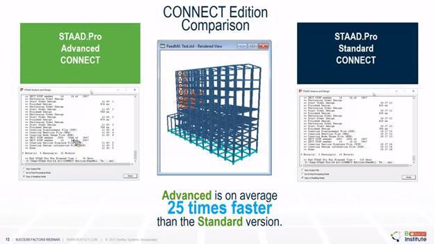
watergems |bentley systems |openflow |SewerGEMS |STAAD PRO |STAAD PRO ADVANCED CONNECT EDITION |STAAD PRO CONNECT EDITION |BENTLEY SYSTEMS |STAAD.Pro Advanced |STAAD |RCDC |BENTLEY STAAD PRO |STRUCTURAL DESIGN |RCC DETAILING |STAAD.Pro |RCC DESIGN AND DETAILING |STAAD PLANWIN |STTAD ADVANCED CONCRETE DESIGN |STAAD ADVANCED ANALYSIS PLUS |CONNECT EDITION |STAAD PRO ADVANCED |STRUCTURAL ENTERPRISE |RCDC FE |STAAD FOUNDATION ADVANCED |STRUCTURAL DESIGN SOFTWARE |E-TEB |BENTLEY |E-TAB |BUY STAAD PRO |Openroads |infraworks |openroads designer |mxroad |mxroad suite |road design software |staad pro |bentley openroads |openroads conceptstation |bentley |civil 3d |AUTOCAD |MICROSTATION V8I |MICROSTATION |OPENROADS |POWERDRAFT |MXROAD |CAD SOFTWARE |BIM |MICROSTATION CONNECT EDITION |DRAWING SOFTWARE |3D MODELING |BIM MODEL |VISUALIZATION TOOL |3D MODEL |BIM SOFTWARE |BENTLEY BIM |REVIT |POWER RAIL TRACK |OPENRAIL |OPENROAD |OPENRAIL DESIGNER |MXRAIL |RAIL TRACK |RAIL TRACK SOFTWARE |BENTLEY MXRAIL |RAIL ALIGNMENT SOFTWARE |DESIGN ANA ANALYSIS SOFTWARE |OpenBuilding |openrail conceptstation |mxrail |connect edition |power rail track |openrail |rail conceptual design |openroads |bentley channel partner |bentley reseller |bentley authorized reseller |AutoCAD |bricscad |Autocad alternative |BricsCAD |2d Drafting Software |Open Bridge Designer |OpenBridge |Bentley system |staad.pro |Structural design |SEL |Bnetley Systems |Microstation |lidar software |plaxis 2d |plaxis 3d |Plaxis Software |Plaxis 3d |Bentley software |Geotechnical Software |Hydraulic design |water distribution

Have any question or need any business consultation?

Have any question or need any business consultation?

Contact Us